
Mappa topografica Quorn
Clicca sulla mappa per visualizzare l'altitudine.
A proposito di questa mappa
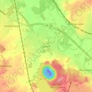
Nome: Mappa topografica Quorn, altitudine, rilievo.
Altitudine media: 55 m
Altitudine minima: -59 m
Altitudine massima: 102 m
Altre mappe topografiche
Clicca su una mappa per visualizzarne la topografia, l'altitudine e il rilievo.
Watermead Country Park
United Kingdom > England > Leicestershire > Charnwood > Birstall
Altitudine media: 59 m
South Croxton
United Kingdom > England > Leicestershire > Charnwood > South Croxton
The highest point is the church, at 120 m above mean sea level. The lowest altitude is 85 m by the Queniborough Brook.
Altitudine media: 108 m
Queniborough
United Kingdom > England > Leicestershire > Charnwood > Queniborough
Altitudine media: 75 m
Beeby
United Kingdom > England > Leicestershire > Charnwood
The physical and historical development of the hamlet has been strongly influenced by the local topography and its relative isolation. Beeby is situated within an established agricultural landscape largely in pastoral use. Until 1904 the east-west route was the only route through the hamlet, which was referred…
Altitudine media: 101 m
Barrow upon Soar
United Kingdom > England > Leicestershire > Charnwood > Barrow upon Soar
Altitudine media: 62 m
Bradgate Park
United Kingdom > England > Leicestershire > Charnwood > Newtown Linford
Overlying the Beacon Hill Formation, but found a little further down the hillside to the south, are the Bradgate Formation beds, the most notable of which is the Sliding Stone Slump Breccia rocks. Forming a line of crags below Old John, these are laminated mudstones, with layers of sandstone, mainly of…
Altitudine media: 126 m
Top Town Plantation
United Kingdom > England > Leicestershire > Charnwood > Walton on the Wolds
Altitudine media: 85 m
Mountsorrel
United Kingdom > England > Leicestershire > Charnwood > Mountsorrel
Altitudine media: 57 m
Moat Hill Spinney
United Kingdom > England > Leicestershire > Charnwood > Cotes
Altitudine media: 50 m
Lea Wood
United Kingdom > England > Leicestershire > Charnwood > Newtown Linford
Altitudine media: 170 m
Charnwood Water
United Kingdom > England > Leicestershire > Charnwood > Woodthorpe
Altitudine media: 47 m
East Goscote
United Kingdom > England > Leicestershire > Charnwood > East Goscote
Altitudine media: 61 m
Swithland Wood
United Kingdom > England > Leicestershire > Charnwood > Swithland
Altitudine media: 107 m
Beacon Hill Country Park
United Kingdom > England > Leicestershire > Charnwood > Woodhouse Eaves
Altitudine media: 164 m
Barrow upon Soar
United Kingdom > England > Leicestershire > Charnwood > Barrow upon Soar
Altitudine media: 62 m