
Mappa topografica Beeby
Clicca sulla mappa per visualizzare l'altitudine.
Beeby
The physical and historical development of the hamlet has been strongly influenced by the local topography and its relative isolation. Beeby is situated within an established agricultural landscape largely in pastoral use. Until 1904 the east-west route was the only route through the hamlet, which was referred to as the Main Road or Barkby Road, connecting the village to Barkby (neighbouring village) and South Croxton. The other roads that now run through Beeby are Hungarton Road, situated to the east and Scraptoft Road, to the south giving the village a more direct link to the outskirts of Leicester. This isolation has mitigated the villages growth over time. This as well as several clusters of cottages and Brewery cottages mixed with informal and open grouping of farmhouses and their associating buildings are features which give this isolated village its character and appeal.
A proposito di questa mappa
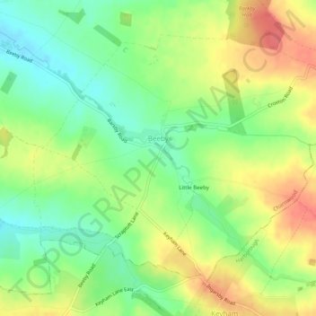
Nome: Mappa topografica Beeby, altitudine, rilievo.
Luogo: Beeby, Charnwood, Leicestershire, England, United Kingdom (52.65503 -1.04068 52.67839 -0.99153)
Altitudine media: 101 m
Altitudine minima: 72 m
Altitudine massima: 134 m
Altre mappe topografiche
Clicca su una mappa per visualizzarne la topografia, l'altitudine e il rilievo.
Watermead Country Park
United Kingdom > England > Leicestershire > Charnwood > Birstall
Altitudine media: 59 m
Bradgate Park
United Kingdom > England > Leicestershire > Charnwood > Newtown Linford
Overlying the Beacon Hill Formation, but found a little further down the hillside to the south, are the Bradgate Formation beds, the most notable of which is the Sliding Stone Slump Breccia rocks. Forming a line of crags below Old John, these are laminated mudstones, with layers of sandstone, mainly of…
Altitudine media: 126 m
Top Town Plantation
United Kingdom > England > Leicestershire > Charnwood > Walton on the Wolds
Altitudine media: 85 m
Moat Hill Spinney
United Kingdom > England > Leicestershire > Charnwood > Cotes
Altitudine media: 50 m
Lea Wood
United Kingdom > England > Leicestershire > Charnwood > Newtown Linford
Altitudine media: 170 m
Old John
United Kingdom > England > Leicestershire > Charnwood > Newtown Linford
Altitudine media: 143 m
Six Hills
United Kingdom > England > Leicestershire > Charnwood > Burton on the Wolds
Altitudine media: 128 m
Swithland Wood
United Kingdom > England > Leicestershire > Charnwood > Swithland
Altitudine media: 107 m
Beacon Hill Country Park
United Kingdom > England > Leicestershire > Charnwood > Woodhouse Eaves
Altitudine media: 164 m