
Mappa topografica Conservation Area
Clicca sulla mappa per visualizzare l'altitudine.
A proposito di questa mappa
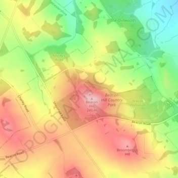
Nome: Mappa topografica Conservation Area, altitudine, rilievo.
Altitudine media: 168 m
Altitudine minima: 75 m
Altitudine massima: 247 m
Altre mappe topografiche
Clicca su una mappa per visualizzarne la topografia, l'altitudine e il rilievo.
South Croxton
United Kingdom > England > Leicestershire > Charnwood > South Croxton
The highest point is the church, at 120 m above mean sea level. The lowest altitude is 85 m by the Queniborough Brook.
Altitudine media: 108 m
Queniborough
United Kingdom > England > Leicestershire > Charnwood > Queniborough
Altitudine media: 75 m
Beeby
United Kingdom > England > Leicestershire > Charnwood
The physical and historical development of the hamlet has been strongly influenced by the local topography and its relative isolation. Beeby is situated within an established agricultural landscape largely in pastoral use. Until 1904 the east-west route was the only route through the hamlet, which was referred…
Altitudine media: 101 m
Barrow upon Soar
United Kingdom > England > Leicestershire > Charnwood > Barrow upon Soar
Altitudine media: 62 m
Mountsorrel
United Kingdom > England > Leicestershire > Charnwood > Mountsorrel
Altitudine media: 57 m
Charnwood Water
United Kingdom > England > Leicestershire > Charnwood > Woodthorpe
Altitudine media: 47 m
Old John
United Kingdom > England > Leicestershire > Charnwood > Newtown Linford
Altitudine media: 143 m
Six Hills
United Kingdom > England > Leicestershire > Charnwood > Burton on the Wolds
Altitudine media: 128 m
East Goscote
United Kingdom > England > Leicestershire > Charnwood > East Goscote
Altitudine media: 61 m
Barrow upon Soar
United Kingdom > England > Leicestershire > Charnwood > Barrow upon Soar
Altitudine media: 62 m