
Mappa topografica Rothley
Clicca sulla mappa per visualizzare l'altitudine.
A proposito di questa mappa
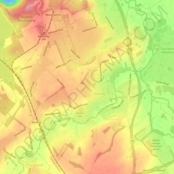
Nome: Mappa topografica Rothley, altitudine, rilievo.
Luogo: Rothley, Charnwood, Leicestershire, England, United Kingdom (52.69276 -1.17440 52.72932 -1.11832)
Altitudine media: 64 m
Altitudine minima: -22 m
Altitudine massima: 102 m
Altre mappe topografiche
Clicca su una mappa per visualizzarne la topografia, l'altitudine e il rilievo.
Watermead Country Park
United Kingdom > England > Leicestershire > Charnwood > Birstall
Altitudine media: 59 m
Bradgate Park
United Kingdom > England > Leicestershire > Charnwood > Newtown Linford
Overlying the Beacon Hill Formation, but found a little further down the hillside to the south, are the Bradgate Formation beds, the most notable of which is the Sliding Stone Slump Breccia rocks. Forming a line of crags below Old John, these are laminated mudstones, with layers of sandstone, mainly of…
Altitudine media: 126 m
Top Town Plantation
United Kingdom > England > Leicestershire > Charnwood > Walton on the Wolds
Altitudine media: 85 m
Moat Hill Spinney
United Kingdom > England > Leicestershire > Charnwood > Cotes
Altitudine media: 50 m
Lea Wood
United Kingdom > England > Leicestershire > Charnwood > Newtown Linford
Altitudine media: 170 m
Old John
United Kingdom > England > Leicestershire > Charnwood > Newtown Linford
Altitudine media: 143 m
Six Hills
United Kingdom > England > Leicestershire > Charnwood > Burton on the Wolds
Altitudine media: 128 m
Swithland Wood
United Kingdom > England > Leicestershire > Charnwood > Swithland
Altitudine media: 107 m
Beacon Hill Country Park
United Kingdom > England > Leicestershire > Charnwood > Woodhouse Eaves
Altitudine media: 164 m