
Mappa topografica Brazos River
Mappa interattiva
Clicca sulla mappa per visualizzare l'altitudine.
A proposito di questa mappa
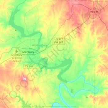
Nome: Mappa topografica Brazos River, altitudine, rilievo.
Luogo: Brazos River, Hood County, Texas, 76048, United States (32.31396 -97.83355 32.55753 -97.60337)
Altitudine media: 256 m
Altitudine minima: 179 m
Altitudine massima: 375 m
Altre mappe topografiche
Clicca su una mappa per visualizzarne la topografia, l'altitudine e il rilievo.
Houston
United States > Texas > Harris County
Houston is characterized by its predominantly flat topography, sitting at an average elevation of approximately 59 feet (18 meters) above sea level. The city is situated on the Gulf Coastal Plain, which is dissected by a network of bayous that contribute to the region's drainage. This terrain was once covered…
Altitudine media: 25 m
Austin
United States > Texas > Travis County
Austin features a diverse and varied topography shaped by its position along the Balcones Fault. The city’s elevation ranges from about 425 feet to approximately 1,000 feet above sea level, creating a landscape characterized by rolling hills and elevated areas particularly in the western regions. To the…
Altitudine media: 216 m
Kerrville
United States > Texas > Kerr County
Kerrville is characterized by a diverse and rugged topography. Nestled along the Guadalupe River, it sits at an elevation averaging 1,600 feet above sea level, with varying terrain that includes gentle hills, steep slopes, and flat river valleys. This area features numerous limestone hills, characteristic of…
Altitudine media: 545 m
Dallas
United States > Texas > Dallas County
Dallas features a predominantly flat terrain characterized by elevations generally ranging from 450 to 550 feet (137 to 168 meters) above sea level. The landscape is shaped significantly by the western edge of the Austin Chalk Formation, a limestone escarpment known as the White Rock Escarpment, which rises…
Altitudine media: 160 m
Houston
United States > Texas > Harris County
Houston is characterized by its predominantly flat topography, sitting at an average elevation of approximately 59 feet (18 meters) above sea level. The city is situated on the Gulf Coastal Plain, which is dissected by a network of bayous that contribute to the region's drainage. This terrain was once covered…
Altitudine media: 25 m
San Antonio
United States > Texas > Bexar County
San Antonio features a diverse topography characterized by gently rolling hills and flat plains. The city's elevation averages around 650 feet above sea level, but nearby areas can reach heights of up to 1,300 feet in certain locations like Cross Mountain. The landscape is part of the southern edge of the…
Altitudine media: 247 m
Georgetown
United States > Texas > Williamson County
Georgetown lies in the central part of Williamson County and features a diverse topography influenced by the Balcones Escarpment. The city itself sits at an average elevation of about 800 feet (244 meters), with its terrain ranging from flatter areas in the east to more hilly and karst-like features in the…
Altitudine media: 247 m
Conroe
United States > Texas > Montgomery County
Conroe features a predominantly flat terrain with an average elevation of approximately 220 feet (67 meters) above sea level. The area is characterized by gently rolling hills interspersed with numerous lakes and wetlands, including the prominent Lake Conroe, which spans about 21,000 acres. The lake, formed by…
Altitudine media: 62 m
San Marcos
United States > Texas > Hays County
San Marcos is characterized by its diverse topography, which includes rolling hills, lush riverbanks, and scenic limestone outcroppings. The city is situated at an elevation of approximately 600 feet above sea level, providing a backdrop of gently undulating terrain that slopes towards the banks of the San…
Altitudine media: 208 m
Palestine
United States > Texas > Anderson County
About 40% of the content from the 2003 Space Shuttle Columbia disaster was recovered, seven astronauts were killed in the accident. Debris from Columbia was found in and outside Palestine and other East Texas towns. Palestine's NASA Columbia Scientific Balloon Facility (renamed in honor of the shuttle crew),…
Altitudine media: 136 m
Travis County
Travis County features a varied and dynamic topography characterized by rolling hills, lush valleys, and significant water features. The terrain rises gently from the flatlands in the east to the more rugged and elevated areas in the west, reaching elevations of up to about 1,400 feet above sea level. The…
Altitudine media: 231 m
Lago Vista
United States > Texas > Travis County
Lago Vista is situated on the northern shore of Lake Travis within the Texas Hill Country. The area's terrain is notably rugged, with steep limestone hills and canyons. Elevations range from about 774 feet near the lake to 1,220 feet near Rusty Allen Airport, making it one of the highest points in Travis…
Altitudine media: 251 m
Montgomery County
Montgomery County features a predominantly flat terrain, with average elevations ranging from about 100 to 350 feet above sea level. The landscape is gently rolling, particularly towards the northern areas, and is interspersed with several lakes, such as the expansive Lake Conroe. This large reservoir, formed…
Altitudine media: 69 m
Round Rock
United States > Texas > Williamson County
Round Rock sits at an approximate elevation of 735 feet above sea level and spans a diverse terrain shaped by the Balcones Escarpment. This geological fault line divides the city into two distinct landscapes: the eastern side lies on the relatively flat and fertile Blackland Prairie, characterized by deep,…
Altitudine media: 242 m
Dallas
United States > Texas > Dallas County
Dallas and its surrounding area are mostly flat. The city lies at elevations ranging from 450 to 550 feet (137 to 168 m) above sea level. The western edge of the Austin Chalk Formation, a limestone escarpment (also known as the "White Rock Escarpment"), rises 230 feet (70 m) and runs roughly north–south…
Altitudine media: 160 m
Lubbock
United States > Texas > Lubbock County
Summers are hot, with 78 afternoons on average of 90 °F (32.2 °C)+ highs and 7.4 afternoons of 100 °F (37.8 °C)+ highs, although due to the aridity and elevation, temperatures remain above 70 °F (21.1 °C) on only a few mornings. Lubbock is the 10th-windiest city in the US with an average wind speed of…
Altitudine media: 983 m
Amarillo
United States > Texas > Potter County
Amarillo features a unique topography characterized by its high elevation and flat plains. The city averages around 3,600 feet (1,097 meters) above sea level, making it one of the highest major cities in Texas. The surrounding landscape consists of the Llano Estacado, a vast tabletop plateau that slopes…
Altitudine media: 1’098 m
Corpus Christi
United States > Texas > Nueces County
Corpus Christi features a diverse coastal topography characterized by its proximity to the Gulf of Mexico. The landscape includes sandy beaches, barrier islands, and extensive estuarine systems such as the Nueces Estuary and Corpus Christi Bay, which are crucial habitats for wildlife. The region is…
Altitudine media: 8 m
Plano
United States > Texas > Collin County
At first, Plano's population grew slowly, reaching 1,304 in 1900 and 3,695 in 1960. By 1970, Plano began to feel some of the boom its neighbors had experienced after World War II. A series of public works projects and a change in taxes that removed the farming community from the town helped increase the…
Altitudine media: 196 m
Frisco
United States > Texas > Collin County
In 1902, a line of the St. Louis-San Francisco Railway was being built through the area, and periodic watering stops were needed along the route for the steam locomotives. The current settlement of Lebanon was on the Preston Ridge, and was too high in elevation, so the watering stop was placed about 4 miles (6…
Altitudine media: 201 m
Austin
United States > Texas > Travis County
The elevation of Austin varies from 425 feet (130 m) to approximately 1,000 feet (305 m) above sea level. Due to the fact it straddles the Balcones Fault, much of the eastern part of the city is flat, with heavy clay and loam soils, whereas the western part and western suburbs consist of rolling hills on the…
Altitudine media: 216 m
Rockport
United States > Texas > Aransas County
The topography of Rockport, Texas, is defined by its flat, coastal terrain, with the city's average elevation being around 20 feet above sea level. The land is largely shaped by the proximity to the Gulf of Mexico, which influences the area's low-lying nature, including some areas below sea level. The…
Altitudine media: 3 m
Sugar Land
United States > Texas > Fort Bend County
Sugar Land is located in northeast Fort Bend County, 20 miles (32 km) southwest of downtown Houston. It is bordered by Houston to the northeast, and by Stafford, Missouri City, and Meadows Place to the east. According to the United States Census Bureau, the city of Sugar Land has a total area of 34.0 square…
Altitudine media: 24 m
The Woodlands
United States > Texas > Montgomery County
The Woodlands is in a heavily forested area, and much of the community has retained trees for shade and decoration. The terrain is essentially flat, with the exception of topographic variations ranging from 125 to 175 feet above sea level between Spring Creek and Flintridge Drive.
Altitudine media: 47 m
Tomball
United States > Texas > Harris County
Settlement began in the Tomball area in the early 19th century, where settlers found an open, fertile land that received adequate rainfall—perfect conditions for farming and raising cattle. It was on a land granted in 1838 to William Hurd's heirs. In 1906 the area began to boom. Railroad line engineers often…
Altitudine media: 52 m
Seguin
United States > Texas > Guadalupe County
The elevation at the courthouse is 522 feet (159 m) above mean sea level.
Altitudine media: 172 m
Williamson County
The area is divided into two regions by the Balcones Escarpment, which runs through the center from north to south along a line from Jarrell to Georgetown to Round Rock. The county's western half is an extension of the Western Plains and considered to be within the eastern fringes of Texas Hill Country; it has…
Altitudine media: 222 m
Fredericksburg
United States > Texas > Gillespie County
Enchanted Rock is a geographical landmark 27 km (17 mi) north of Fredericksburg in Llano County. The rock is a huge, pink granite exfoliation dome that rises 425 ft (130 m) above the surrounding land, has a summit elevation of 1,825 ft (556 m) above sea level, and covers 640 acres (260 ha). Enchanted Rock…
Altitudine media: 526 m
Cedar Hill
United States > Texas > Dallas County
The city is sometimes referred to as the "hill country of Dallas" (in comparison to the "hill country" surrounding Austin and San Antonio). The city is full of native eastern red cedar evergreen trees and stands at an elevation of about 800 feet (240 m) above sea level—the highest point in a straight line…
Altitudine media: 214 m
Galveston
United States > Texas > Galveston County
On September 8, 1900, the island was struck by a devastating hurricane. This event holds the record as the United States' deadliest natural disaster. The city was devastated, and an estimated 6,000 to 8,000 people on the island were killed. Following the storm, a 10-mile (16 km) long, 17 foot (5.2 m) high…
Altitudine media: 1 m
El Paso
United States > Texas > El Paso County
El Paso is characterized by a diverse and striking topography shaped by its desert environment and mountainous landscapes. The city is situated at an average elevation of approximately 3,700 feet above sea level, surrounded by the rugged Franklin Mountains to the west, where peaks exceed 7,000 feet. This…
Altitudine media: 1’237 m