
Mappa topografica Brazos County
Clicca sulla mappa per visualizzare l'altitudine.
A proposito di questa mappa
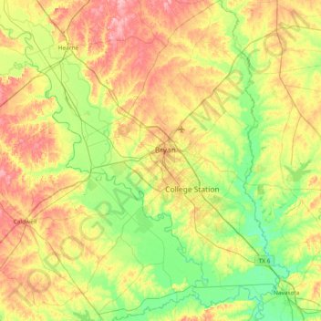
Nome: Mappa topografica Brazos County, altitudine, rilievo.
Luogo: Brazos County, Texas, United States (30.33056 -96.60184 30.97397 -96.07991)
Altitudine media: 90 m
Altitudine minima: 45 m
Altitudine massima: 161 m
Altre mappe topografiche
Clicca su una mappa per visualizzarne la topografia, l'altitudine e il rilievo.
Georgetown
United States > Texas > Georgetown
The city is located on the northeastern edge of Texas Hill Country. Portions of Georgetown are located on either side of the Balcones Escarpment, a fault line in which the areas roughly east of IH-35 are flat and characterized by having black, fertile soils of the Blackland Prairie, and the west side of the…
Altitudine media: 219 m
Enchanted Rock
United States > Texas > Llano County
Enchanted Rock is a pink granite mountain located in the Llano Uplift about 17 miles (27 km) north of Fredericksburg, Texas and 24 miles (39 km) south of Llano, Texas, United States. Enchanted Rock State Natural Area, which includes Enchanted Rock and surrounding land, spans the border between Gillespie and…
Altitudine media: 453 m
Padre Island National Seashore
United States > Texas > Kenedy County > Corpus Christi
Altitudine media: 5 m
Choke Canyon State Park - Calliham Unit
United States > Texas > McMullen County > Calliham
Altitudine media: 67 m
Mineral Wells Fossil Park
United States > Texas > Palo Pinto County > Mineral Wells
Altitudine media: 283 m