
Mappa topografica Georgetown
Clicca sulla mappa per visualizzare l'altitudine.
Georgetown
Georgetown lies in the central part of Williamson County and features a diverse topography influenced by the Balcones Escarpment. The city itself sits at an average elevation of about 800 feet (244 meters), with its terrain ranging from flatter areas in the east to more hilly and karst-like features in the west. The landscape is shaped by the presence of several creeks and rivers, notably the San Gabriel River, which winds through the city and contributes to local topographical variation. The eastern portions are generally part of the Blackland Prairie, known for its fertile, flat land ideal for agriculture. To the west, the terrain becomes more rugged with steeper slopes and limestone outcrops. This region's combination of lowland prairie and more challenging hill-country terrain contributes to Georgetown's scenic beauty and its appeal for both development and outdoor activities.
A proposito di questa mappa
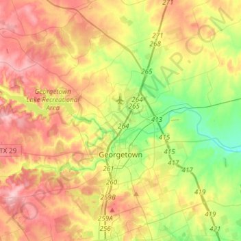
Nome: Mappa topografica Georgetown, altitudine, rilievo.
Luogo: Georgetown, Williamson County, Texas, United States (30.57080 -97.83279 30.75254 -97.58988)
Altitudine media: 247 m
Altitudine minima: 176 m
Altitudine massima: 322 m
Altre mappe topografiche
Clicca su una mappa per visualizzarne la topografia, l'altitudine e il rilievo.
Georgetown
United States > Texas > Williamson County > Georgetown
The city is located on the northeastern edge of Texas Hill Country. Portions of Georgetown are located on either side of the Balcones Escarpment, a fault line in which the areas roughly east of IH-35 are flat and characterized by having black, fertile soils of the Blackland Prairie, and the west side of the…
Altitudine media: 228 m
Soil Conservation Service Site 12 Dam
United States > Texas > Williamson County > Type
Altitudine media: 173 m
Soil Conservation Service Site 12 Dam
United States > Texas > Williamson County > Type
Altitudine media: 173 m
Soil Conservation Service Site 12 Dam
United States > Texas > Williamson County > Type
Altitudine media: 173 m