
Mappa topografica Round Rock
Clicca sulla mappa per visualizzare l'altitudine.
Round Rock
Round Rock sits at an approximate elevation of 735 feet above sea level and spans a diverse terrain shaped by the Balcones Escarpment. This geological fault line divides the city into two distinct landscapes: the eastern side lies on the relatively flat and fertile Blackland Prairie, characterized by deep, clay-rich soils ideal for agriculture. In contrast, the western side features the rugged, limestone-rich topography of the Texas Hill Country, where rolling hills and exposed bedrock are common. This variance in elevation and terrain not only creates a unique visual landscape but also influences local ecosystems and land use across the city.
A proposito di questa mappa
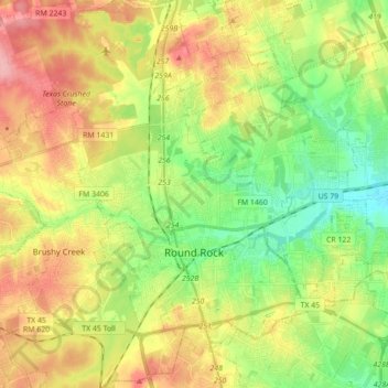
Nome: Mappa topografica Round Rock, altitudine, rilievo.
Luogo: Round Rock, Williamson County, Texas, United States (30.46829 -97.76484 30.59378 -97.59005)
Altitudine media: 242 m
Altitudine minima: 191 m
Altitudine massima: 306 m
Altre mappe topografiche
Clicca su una mappa per visualizzarne la topografia, l'altitudine e il rilievo.
Georgetown
United States > Texas > Williamson County > Georgetown
The city is located on the northeastern edge of Texas Hill Country. Portions of Georgetown are located on either side of the Balcones Escarpment, a fault line in which the areas roughly east of IH-35 are flat and characterized by having black, fertile soils of the Blackland Prairie, and the west side of the…
Altitudine media: 228 m
Soil Conservation Service Site 12 Dam
United States > Texas > Williamson County > Type
Altitudine media: 173 m
Soil Conservation Service Site 12 Dam
United States > Texas > Williamson County > Type
Altitudine media: 173 m
Soil Conservation Service Site 12 Dam
United States > Texas > Williamson County > Type
Altitudine media: 173 m