
Mappa topografica Villa Rica
Clicca sulla mappa per visualizzare l'altitudine.
Villa Rica
The District of Villa Rica is on the eastern slopes of the Andes mountains in an area of abundant rainfall and mild temperatures. It is located in the ecological zone of the Peruvian Yungas, or Ceja de Selva ("eyebrow of the jungle"), the transition zone between the low jungles of the Amazon Basin and the Andes highlands. Elevations in the district range from about 800 metres (2,600 ft) to about 2,400 metres (7,900 ft). Where not cleared for agriculture, the vegetation is tropical and sub-tropical forests.
A proposito di questa mappa
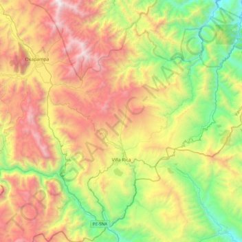
Nome: Mappa topografica Villa Rica, altitudine, rilievo.
Luogo: Villa Rica, Province of Oxapampa, Pasco, Peru (-10.86608 -75.40957 -10.48042 -75.02797)
Altitudine media: 1’708 m
Altitudine minima: 505 m
Altitudine massima: 3’346 m
Altre mappe topografiche
Clicca su una mappa per visualizzarne la topografia, l'altitudine e il rilievo.
Cerro de Pasco
Cerro de Pasco is a city in central Peru, located at the top of the Andean Mountains. It is the capital of both the Pasco Province and the Department of Pasco, and an important mining center of silver, copper, zinc and lead. At an elevation of 4,330 metres (14,210 ft), it is one of the highest cities in the…
Altitudine media: 4’239 m