
Mappa topografica Chango
Clicca sulla mappa per visualizzare l'altitudine.
A proposito di questa mappa
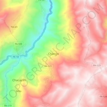
Nome: Mappa topografica Chango, altitudine, rilievo.
Luogo: Chango, Chacayán, Province of Daniel Carrión, Pasco, Peru (-10.45451 -76.45126 -10.37451 -76.37126)
Altitudine media: 3’621 m
Altitudine minima: 2’677 m
Altitudine massima: 4’320 m
Altre mappe topografiche
Clicca su una mappa per visualizzarne la topografia, l'altitudine e il rilievo.
Villa Rica
The District of Villa Rica is on the eastern slopes of the Andes mountains in an area of abundant rainfall and mild temperatures. It is located in the ecological zone of the Peruvian Yungas, or Ceja de Selva ("eyebrow of the jungle"), the transition zone between the low jungles of the Amazon Basin and the…
Altitudine media: 1’708 m
Province of Oxapampa
Oxapampa is the largest of three provinces that make up the Pasco Region in Peru. The capital of the province is the city of Oxapampa. The province is located on the eastern slopes of the Andes reaching down to the lowlands of the Amazon Basin. The high point of the province is approximately 5,300 metres…
Altitudine media: 1’348 m
Villa Rica
The District of Villa Rica is on the eastern slopes of the Andes mountains in an area of abundant rainfall and mild temperatures. It is located in the ecological zone of the Peruvian Yungas, or Ceja de Selva ("eyebrow of the jungle"), the transition zone between the low jungles of the Amazon Basin and the…
Altitudine media: 1’708 m