
Fai una donazione
Equipaggiati per la tua prossima avventura:
In qualità di Affiliato Amazon, questo sito riceve una commissione sugli acquisti idonei, senza costi aggiuntivi per l’utente.
Mappa topografica Cerro de Pasco
Clicca sulla mappa per visualizzare l'altitudine.
Fai una donazione
Equipaggiati per la tua prossima avventura:
In qualità di Affiliato Amazon, questo sito riceve una commissione sugli acquisti idonei, senza costi aggiuntivi per l’utente.
Cerro de Pasco
Cerro de Pasco is a city in central Peru, located at the top of the Andean Mountains. It is the capital of both the Pasco Province and the Department of Pasco, and an important mining center of silver, copper, zinc and lead. At an elevation of 4,330 metres (14,210 ft), it is one of the highest cities in the world, and with a population of 58,899, it is the highest or the second highest city with over 50,000 inhabitants. The elevation reaches up to 4,380 metres or 14,370 feet in the Yanacancha area. The city has a very intense cold climate and it is connected by road and by rail (via Ferrocarril Central Andino) to the capital Lima, 300 kilometres or 190 miles away. Its urban area is formed by the districts of Chaupimarca, Yanacancha and Simón Bolívar.
Fai una donazione
Equipaggiati per la tua prossima avventura:
In qualità di Affiliato Amazon, questo sito riceve una commissione sugli acquisti idonei, senza costi aggiuntivi per l’utente.
A proposito di questa mappa
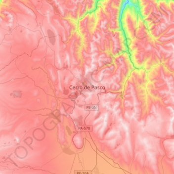
Nome: Mappa topografica Cerro de Pasco, altitudine, rilievo.
Altitudine media: 4’239 m
Altitudine minima: 3’386 m
Altitudine massima: 4’602 m
Fai una donazione
Equipaggiati per la tua prossima avventura:
In qualità di Affiliato Amazon, questo sito riceve una commissione sugli acquisti idonei, senza costi aggiuntivi per l’utente.
Altre mappe topografiche
Clicca su una mappa per visualizzarne la topografia, l'altitudine e il rilievo.
Villa Rica
The District of Villa Rica is on the eastern slopes of the Andes mountains in an area of abundant rainfall and mild temperatures. It is located in the ecological zone of the Peruvian Yungas, or Ceja de Selva ("eyebrow of the jungle"), the transition zone between the low jungles of the Amazon Basin and the…
Altitudine media: 1’708 m
Fai una donazione
Equipaggiati per la tua prossima avventura:
In qualità di Affiliato Amazon, questo sito riceve una commissione sugli acquisti idonei, senza costi aggiuntivi per l’utente.
Province of Oxapampa
Oxapampa is the largest of three provinces that make up the Pasco Region in Peru. The capital of the province is the city of Oxapampa. The province is located on the eastern slopes of the Andes reaching down to the lowlands of the Amazon Basin. The high point of the province is approximately 5,300 metres…
Altitudine media: 1’348 m
Fai una donazione
Equipaggiati per la tua prossima avventura:
In qualità di Affiliato Amazon, questo sito riceve una commissione sugli acquisti idonei, senza costi aggiuntivi per l’utente.
Villa Rica
The District of Villa Rica is on the eastern slopes of the Andes mountains in an area of abundant rainfall and mild temperatures. It is located in the ecological zone of the Peruvian Yungas, or Ceja de Selva ("eyebrow of the jungle"), the transition zone between the low jungles of the Amazon Basin and the…
Altitudine media: 1’708 m
Province of Oxapampa
Oxapampa is the largest of three provinces that make up the Pasco Region in Peru. The capital of the province is the city of Oxapampa. The province is located on the eastern slopes of the Andes reaching down to the lowlands of the Amazon Basin. The high point of the province is approximately 5,300 metres…
Altitudine media: 1’348 m