
Mappa topografica Perth
Clicca sulla mappa per visualizzare l'altitudine.
A proposito di questa mappa
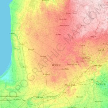
Nome: Mappa topografica Perth, altitudine, rilievo.
Luogo: Perth, Ontario, N0K 1T0, Canada (42.85360 -81.65641 44.13360 -80.37641)
Altitudine media: 313 m
Altitudine minima: 175 m
Altitudine massima: 526 m
Altre mappe topografiche
Clicca su una mappa per visualizzarne la topografia, l'altitudine e il rilievo.
Ottawa
Ottawa, the capital city of Canada, is situated on the south bank of the Ottawa River at the confluence with the Rideau River. The city's topography is characterized by gently rolling terrain with elevations ranging from approximately 44 meters (144 feet) above sea level at the Ottawa River to its highest…
Altitudine media: 105 m
Toronto
Despite its deep ravines, Toronto is not remarkably hilly, but its elevation does increase steadily away from the lake. Elevation differences range from 76.5 metres (251 ft) above sea level at the Lake Ontario shore to 209 m (686 ft) above sea level near the York University grounds in the city's north end at…
Altitudine media: 139 m
Lake Ontario
Lake Ontario is the easternmost of the Great Lakes and the smallest in surface area (7,340 sq mi, 18,960 km2), although it exceeds Lake Erie in volume (393 cu mi, 1,639 km3). It is the 13th largest lake in the world. When its islands are included, the lake's shoreline is 712 miles (1,146 km) long. As the last…
Altitudine media: 214 m
Hamilton
Hamilton's climate is humid-continental, characterized by changeable weather patterns. In the Köppen classification, Hamilton it is on the Dfb/Dfa border found in southern Ontario because the average temperature in July is 22.0 °C (71.6 °F). However, its climate is moderate compared with most of Canada. The…
Altitudine media: 187 m
Lake Nipissing
Canada > Ontario > Nipissing District
Lake Nipissing (/ˈnɪpəsɪŋ/; French: lac Nipissing, Ojibwe: Gichi-nibiinsing-zaaga’igan) is a lake in the Canadian province of Ontario. It has a surface area of 873.3 km2 (337.2 sq mi), a mean elevation of 196 m (643 ft) above sea level, and is located between the Ottawa River and Georgian Bay. Lake…
Altitudine media: 272 m
Kitchener
Canada > Ontario > Region of Waterloo
Kitchener is located in Southwestern Ontario, in the Saint Lawrence Lowlands. This geological and climatic region has wet-climate soils and deciduous forests. Situated in the Grand River Valley, the area is generally above 300 m (1,000 ft) in elevation.
Altitudine media: 336 m
Toronto
Despite its deep ravines, Toronto is not remarkably hilly, but its elevation does increase steadily away from the lake. Elevation differences range from 76.5 metres (251 ft) above sea level at the Lake Ontario shore to 209 m (686 ft) ASL near the York University grounds in the city's north end at the…
Altitudine media: 139 m
Lake Scugog
Canada > Ontario > Durham Region > Kawartha Lakes
The stagnant waters of the lake caused a wave of deadly fevers in the surrounding farms, and the new lake limits quickly became very unpopular with the local residents. On one day in the summer of 1838, settlers from the countryside surrounding the lake rose up and using axes, flintlocks and pitchforks, tore…
Altitudine media: 269 m
lac Seul
Canada > Ontario > Kenora District > Unorganized Kenora District
Lac Seul is a large, crescent shaped reservoir in Kenora District, northwestern Ontario, Canada. It is approximately 241 km (150 mi) long. It has a maximum (regulated) depth of 47.2 m, with a surface elevation of 357 m above sea level. Its level is raised in the summer and then drawn down in the winter months…
Altitudine media: 374 m
North Bay
Canada > Ontario > Nipissing District
The climate in North Bay is common to most places in Northern Ontario. North Bay tends to be a less humid climate than that found in Southern Ontario due somewhat to the distance from the Great Lakes and less warm than some other locations in Northern Ontario due to cooling from Lake Nipissing. On May 31,…
Altitudine media: 266 m
Mississauga
Canada > Ontario > Peel Region
The shoreline of former Glacial Lake Iroquois roughly follows the Dundas Street alignment, although it is not noticeable in some places but is more prominent in others, such as the site of the former brickyard (Shoreline Dr. near Mavis Rd.), the ancient shoreline promenteau affords a clear view of downtown…
Altitudine media: 151 m
Peel Region
The region's climate are influenced by various air masses and weather systems from other locations, proximity to Lake Ontario, topography and elevation (e.g. Niagara Escarpment, and Oak Ridges Moraine), and urban and rural land uses. The air masses and weather systems are the major factors in influencing the…
Altitudine media: 265 m
Scarborough
Topographically, Scarborough is dominated by two watersheds, Highland Creek and the Rouge River. Highland Creek lies almost entirely within Scarborough and occupies approximately 70% of its total area. It occupies the western half of Scarborough, while the Rouge River flows through the eastern portion. Both of…
Altitudine media: 138 m
Newmarket
Canada > Ontario > York Region
Newmarket's geographical coordinates are 44.05°N, 79.46°W, and its elevation above sea level is 252 m. It has an area of 38.33 km². The town is bounded on the south by Aurora, on the west by King, on the north by East Gwillimbury and on the east by Whitchurch–Stouffville.
Altitudine media: 270 m
Hamilton
The airport's open, rural location and higher altitude results in lower temperatures, generally windier conditions, and higher snowfall amounts than lower, built-up areas of the city. The highest temperature ever recorded in Hamilton was 41.1 °C (106 °F) on July 14, 1868. The coldest temperature ever…
Altitudine media: 187 m
Eastern Ontario
Along the extreme western edge of Eastern Ontario is a continuation of the Laurentian Highlands, known as the Opeongo Hills, and they contain some of the highest elevations in Southern Ontario. They stretch into the northern portions of Central Ontario, near Algonquin Provincial Park.
Altitudine media: 243 m
Victoria Lake
Canada > Ontario > Nipissing District > South Algonquin Township
Altitudine media: 407 m
Simcoe County
The road network in Simcoe County is based on a grid pattern, with most roads running north–south or east–west. The topography of the land has permitted roads to be set in predominantly straight lines.
Altitudine media: 265 m
Barrie
On September 7, 1977, a private aircraft, flown by "Army" Hollingsworth, dropped altitude to 500 feet (152 m) in dense fog and struck CKVR's 1,000-foot (305 m) transmitter tower, killing all five people aboard the plane and destroying the tower and antenna. The station's 225-foot (69 m) auxiliary tower was…
Altitudine media: 265 m
St. Catharines
Canada > Ontario > Niagara Region
The most defining transportation icon of St. Catharines is the Welland Canal, a ship canal that runs 43.4 kilometres (27.0 mi), passing through the city. Four of its locks are within city boundaries. The canal allows shipping vessels to traverse the 99.5-metre (326.5 ft) drop in altitude from Lake Erie to Lake…
Altitudine media: 103 m
Whitefish Lake
Canada > Ontario > Thunder Bay District > Unorganized Thunder Bay District
Altitudine media: 472 m
London
London has a humid continental climate (Köppen Dfb), though due to its downwind location relative to Lake Huron and elevation changes across the city, it is virtually on the Dfa/Dfb (hot summer) boundary favouring the former climate zone to the southwest of the confluence of the South and North Thames Rivers,…
Altitudine media: 263 m
Wapikaimaski Lake
Canada > Ontario > Thunder Bay District > Unorganized Thunder Bay District
Altitudine media: 437 m
Markham
Canada > Ontario > York Region
Markham's average altitude is at 200 m (660 ft) and in general consists of gently rolling hills. The city is intersected by two rivers; the Don River and Rouge River, as well as their tributaries. To the north is the Oak Ridges Moraine, which further elevates the elevation towards the north.
Altitudine media: 216 m
Richmond Hill
Canada > Ontario > York Region
The village of Richmond Hill was incorporated by a bylaw of the York County Council on June 18, 1872, coming into effect January 1, 1873. In September 1956, the Ontario Municipal Board approved its elevation to Town status, effective January 1, 1957.
Altitudine media: 256 m
Sarnia
Canada > Ontario > Lambton County
Sarnia is located on the eastern shore of Lake Huron at its extreme southern point, where it flows into the St. Clair River. Most of the surrounding area is flat, and the elevation ranges from 169 metres (554 ft) and 281 metres (922 ft) above sea level. The soil mostly comprises clay. Despite this high…
Altitudine media: 186 m
Silent Lake Provincial Park
Canada > Ontario > Haliburton County > Highlands East
Altitudine media: 371 m
Rideau River
Canada > Ontario > Leeds and Grenville Counties > Merrickville > Merrickville-Wolford
Altitudine media: 109 m
Sunbow Lake
Canada > Ontario > Thunder Bay District > Unorganized Thunder Bay District
Altitudine media: 491 m
Trent Lakes
Canada > Ontario > Peterborough County
The lumber and agricultural industries are significant to the history of the township. Due to the topography of the region, agricultural production was limited to only certain areas where soil conditions were adequate and cattle and mixed farming (orchards, cattle, horses, sheep, grains, vegetables, chickens…
Altitudine media: 293 m
Kirkland Lake
Canada > Ontario > Timiskaming District
Kirkland Lake is located in the resource-rich Precambrian Shield, an ancient geological core of the North American continent. Nearby is the Arctic Watershed, a drainage divide at an elevation of 318 m (1,043 ft). Rivers south of that elevation flow into a drainage basin which includes Lake Ontario and the…
Altitudine media: 332 m