
Mappa topografica lac Seul
Clicca sulla mappa per visualizzare l'altitudine.
lac Seul
Lac Seul is a large, crescent shaped reservoir in Kenora District, northwestern Ontario, Canada. It is approximately 241 km (150 mi) long. It has a maximum (regulated) depth of 47.2 m, with a surface elevation of 357 m above sea level. Its level is raised in the summer and then drawn down in the winter months to reach points of as low as 16 feet below the maximum level. It is the second largest body of water entirely within the province of Ontario (Lake Nipigon being first). The lake consists of open water bays, narrow channels, and islands. It is a relatively shallow lake with many rock shoals. This provides a good habitat for walleye (also known as "yellow pickerel") and northern pike as well as yellow perch. During the Lac Seul project of 1968-1972 no muskelunge were noted in the catches of research nets set over those years. Significant numbers of whitefish, tullibee, burbot and cisco were noted as well although they infrequently were noted in the sport fishery. Lac Seul is noted for offering some of the best fishing in Ontario.
A proposito di questa mappa
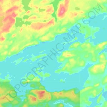
Nome: Mappa topografica lac Seul, altitudine, rilievo.
Altitudine media: 374 m
Altitudine minima: 351 m
Altitudine massima: 431 m
Altre mappe topografiche
Clicca su una mappa per visualizzarne la topografia, l'altitudine e il rilievo.
Chisholm Island
Canada > Ontario > Kenora District > Unorganized Kenora District
Altitudine media: 323 m
Gordon Island
Canada > Ontario > Kenora District > Unorganized Kenora District
Altitudine media: 349 m
Cardinal (Lac) Lake
Canada > Ontario > Kenora District > Unorganized Kenora District
Altitudine media: 392 m
Hudson Bay Lowlands
Canada > Ontario > Kenora District > Unorganized Kenora District
Altitudine media: 17 m
Big Island Lake
Canada > Ontario > Kenora District > Unorganized Kenora District
Altitudine media: 430 m
Clearwater Bay
Canada > Ontario > Kenora District > Unorganized Kenora District
Altitudine media: 334 m
Wabauskang 21
Canada > Ontario > Kenora District > Unorganized Kenora District
Altitudine media: 368 m
Dingwall Island
Canada > Ontario > Kenora District > Unorganized Kenora District
Altitudine media: 325 m
Grindstone Lake
Canada > Ontario > Kenora District > Unorganized Kenora District
Altitudine media: 371 m
Slate Islands
Canada > Ontario > Kenora District > Unorganized Kenora District
Altitudine media: 322 m
Nine Mile Lake
Canada > Ontario > Kenora District > Unorganized Kenora District
Altitudine media: 413 m
Mackey Island
Canada > Ontario > Kenora District > Unorganized Kenora District
Altitudine media: 336 m
Tablerock Lake
Canada > Ontario > Kenora District > Unorganized Kenora District
Altitudine media: 384 m
Little Boulder Lake
Canada > Ontario > Kenora District > Unorganized Kenora District
Altitudine media: 359 m
Cameron Island
Canada > Ontario > Kenora District > Unorganized Kenora District
Altitudine media: 338 m