
Mappa topografica Markham
Clicca sulla mappa per visualizzare l'altitudine.
Markham
Markham's average altitude is at 200 m (660 ft) and in general consists of gently rolling hills. The city is intersected by two rivers; the Don River and Rouge River, as well as their tributaries. To the north is the Oak Ridges Moraine, which further elevates the elevation towards the north.
A proposito di questa mappa
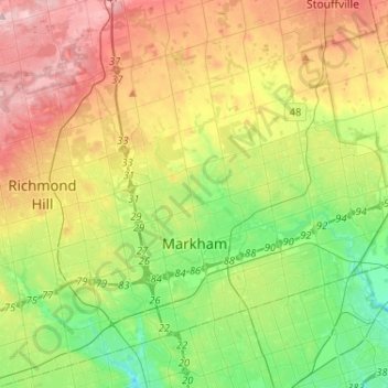
Nome: Mappa topografica Markham, altitudine, rilievo.
Luogo: Markham, York Region, Golden Horseshoe, Ontario, Canada (43.79804 -79.42873 43.96251 -79.17021)
Altitudine media: 216 m
Altitudine minima: 135 m
Altitudine massima: 333 m
Altre mappe topografiche
Clicca su una mappa per visualizzarne la topografia, l'altitudine e il rilievo.
Keswick
Canada > Ontario > York Region
Keswick's geographical coordinates are 44.22°N, 79.45°W, and its elevation above sea level is 221m/762 ft. It has a geographical area of 16.25 km² according to Statistics Canada. It is bound on the north by Roches Point, the east by Woodbine Avenue, the south by East Gwillimbury (Ravenshoe Road) and the…
Altitudine media: 228 m
Whitchurch-Stouffville Community Park, Vandorf
Canada > Ontario > York Region > Whitchurch-Stouffville
Altitudine media: 305 m
East Holland River
Canada > Ontario > York Region > East Gwillimbury > Holland Landing
Altitudine media: 223 m
Phyllis Rawlinson Park
Canada > Ontario > York Region > Richmond Hill > Gormley
Altitudine media: 252 m
Keswick
Canada > Ontario > York Region
Keswick's geographical coordinates are 44.22°N, 79.45°W, and its elevation above sea level is 221m/762 ft. It has a geographical area of 16.25 km² according to Statistics Canada. It is bound on the north by Roches Point, the east by Woodbine Avenue, the south by East Gwillimbury (Ravenshoe Road) and the…
Altitudine media: 228 m