
Mappa topografica Bath
Mappa interattiva
Clicca sulla mappa per visualizzare l'altitudine.
A proposito di questa mappa
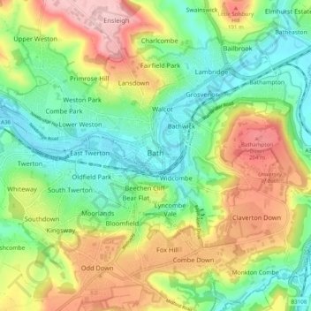
Nome: Mappa topografica Bath, altitudine, rilievo.
Altitudine media: 100 m
Altitudine minima: 14 m
Altitudine massima: 235 m
Bath is in the Avon Valley and is surrounded by limestone hills as it is near the southern edge of the Cotswolds, a designated Area of Outstanding Natural Beauty, and the limestone Mendip Hills rise around 7 miles (11 km) south of the city. The hills that surround and make up the city have a maximum altitude of 781 feet (238 metres) on the Lansdown plateau. Bath has an area of 11 square miles (28 square kilometres).
Altre mappe topografiche
Clicca su una mappa per visualizzarne la topografia, l'altitudine e il rilievo.
Hallatrow
United Kingdom > England > Bath and North East Somerset > High Littleton
Hallatrow, High Littleton, Bath and North East Somerset, West of England, England, BS39 6WD, United Kingdom
Altitudine media: 119 m
Priston
United Kingdom > England > Bath and North East Somerset
Priston, Bath and North East Somerset, West of England, England, United Kingdom
Altitudine media: 106 m
Chew Stoke
United Kingdom > England > Bath and North East Somerset
Chew Stoke, Bath and North East Somerset, West of England, England, United Kingdom
Altitudine media: 78 m
Publow
United Kingdom > England > Bath and North East Somerset
Publow, Bath and North East Somerset, West of England, England, United Kingdom
Altitudine media: 76 m
Monkton Combe
United Kingdom > England > Bath and North East Somerset
Monkton Combe, Bath and North East Somerset, West of England, England, United Kingdom
Altitudine media: 102 m
Stowey
United Kingdom > England > Bath and North East Somerset
Stowey, Bath and North East Somerset, West of England, England, BS39 5TH, United Kingdom
Altitudine media: 109 m
Tadwick
United Kingdom > England > Bath and North East Somerset > Swainswick
Tadwick, Swainswick, Bath and North East Somerset, West of England, England, BA1 8AH, United Kingdom
Altitudine media: 161 m
Carlingcott
United Kingdom > England > Bath and North East Somerset > Peasedown St. John
Carlingcott, Peasedown St. John, Bath and North East Somerset, West of England, England, BA2 8AW, United Kingdom
Altitudine media: 123 m
Wellow
United Kingdom > England > Bath and North East Somerset
Wellow, Bath and North East Somerset, West of England, England, United Kingdom
Altitudine media: 99 m
North Wick
United Kingdom > England > Bath and North East Somerset > Chew Magna
North Wick, Chew Magna, Bath and North East Somerset, West of England, England, BS41 8NN, United Kingdom
Altitudine media: 110 m
Compton Martin
United Kingdom > England > Bath and North East Somerset
Compton Martin, Bath and North East Somerset, West of England, England, United Kingdom
Altitudine media: 105 m
Hinton Charterhouse
United Kingdom > England > Bath and North East Somerset
Hinton Charterhouse, Bath and North East Somerset, West of England, England, United Kingdom
Altitudine media: 94 m
Southstoke
United Kingdom > England > Bath and North East Somerset
Southstoke, Bath and North East Somerset, West of England, England, United Kingdom
Altitudine media: 111 m
Mearns
United Kingdom > England > Bath and North East Somerset > Farmborough
Mearns, Farmborough, Bath and North East Somerset, West of England, England, BS39 6JR, United Kingdom
Altitudine media: 129 m
Chewton Keynsham
United Kingdom > England > Bath and North East Somerset > Compton Dando
Chewton Keynsham, Compton Dando, Bath and North East Somerset, West of England, England, BS31 2SW, United Kingdom
Altitudine media: 57 m
Cameley
United Kingdom > England > Bath and North East Somerset
Cameley, Bath and North East Somerset, West of England, England, United Kingdom
Altitudine media: 130 m
Bathampton
United Kingdom > England > Bath and North East Somerset
Bathampton, Bath and North East Somerset, West of England, England, United Kingdom
Altitudine media: 74 m
Whitley Batts
United Kingdom > England > Bath and North East Somerset > Pensford
Whitley Batts, Publow, Pensford, Bath and North East Somerset, West of England, England, BS39 4NE, United Kingdom
Altitudine media: 87 m
Timsbury
United Kingdom > England > Bath and North East Somerset
Timsbury, Bath and North East Somerset, West of England, England, United Kingdom
Altitudine media: 127 m
Chelwood
United Kingdom > England > Bath and North East Somerset
Chelwood, Bath and North East Somerset, West of England, England, United Kingdom
Altitudine media: 107 m
Wick Green
United Kingdom > England > Bath and North East Somerset > Bishop Sutton
Wick Green, Stowey-Sutton, Bishop Sutton, Bath and North East Somerset, West of England, England, BS39 5XR, United Kingdom
Altitudine media: 82 m
Bathwick Hill
United Kingdom > England > Bath and North East Somerset > Bath
Bathwick Hill, Bathwick, Bath, Bath and North East Somerset, West of England, England, BA2 6JY, United Kingdom
Altitudine media: 93 m
Sydney Gardens
United Kingdom > England > Bath and North East Somerset > Bath
Sydney Gardens, Bathwick, Bath, Bath and North East Somerset, West of England, England, United Kingdom
Altitudine media: 77 m
Sharpstone
United Kingdom > England > Bath and North East Somerset > Freshford
Sharpstone, Freshford, Bath and North East Somerset, West of England, England, BA2 7UA, United Kingdom
Altitudine media: 93 m
Chew Magna
United Kingdom > England > Bath and North East Somerset
Chew Magna, Bath and North East Somerset, West of England, England, United Kingdom
Altitudine media: 90 m
Saltford
United Kingdom > England > Bath and North East Somerset > Saltford
Saltford, Bath and North East Somerset, South West England, England, United Kingdom
Altitudine media: 42 m
Little Solsbury Hill
United Kingdom > England > Bath and North East Somerset > Batheaston
Little Solsbury Hill, Batheaston, Bath and North East Somerset, West of England, England, BA1 7JQ, United Kingdom
Altitudine media: 88 m
Radstock
United Kingdom > England > Bath and North East Somerset
Radstock, Bath and North East Somerset, West of England, England, United Kingdom
Altitudine media: 117 m
Compton Dando
United Kingdom > England > Bath and North East Somerset
Compton Dando, Bath and North East Somerset, West of England, England, United Kingdom
Altitudine media: 68 m
Keynsham
United Kingdom > England > Bath and North East Somerset
Keynsham, Bath and North East Somerset, West of England, England, United Kingdom
Altitudine media: 46 m
Batheaston
United Kingdom > England > Bath and North East Somerset
Batheaston, Bath and North East Somerset, West of England, England, United Kingdom
Altitudine media: 114 m
Maes Knoll
United Kingdom > England > Bath and North East Somerset > Norton Malreward
Maes Knoll, Norton Malreward, Bath and North East Somerset, South West England, England, BS39 4EY, United Kingdom
Altitudine media: 110 m
Nempnett Thrubwell
United Kingdom > England > Bath and North East Somerset
Nempnett Thrubwell, Bath and North East Somerset, West of England, England, United Kingdom
Altitudine media: 111 m
Midsomer Norton
United Kingdom > England > Bath and North East Somerset
Midsomer Norton, Bath and North East Somerset, West of England, England, United Kingdom
Altitudine media: 114 m
High Littleton
United Kingdom > England > Bath and North East Somerset
High Littleton, Bath and North East Somerset, West of England, England, United Kingdom
Altitudine media: 122 m
Peasedown St. John
United Kingdom > England > Bath and North East Somerset
Peasedown St. John, Bath and North East Somerset, West of England, England, United Kingdom
Altitudine media: 125 m
Hinton Blewett
United Kingdom > England > Bath and North East Somerset
Hinton Blewett, Bath and North East Somerset, West of England, England, United Kingdom
Altitudine media: 121 m
Norton Malreward
United Kingdom > England > Bath and North East Somerset
Norton Malreward, Bath and North East Somerset, West of England, England, United Kingdom
Altitudine media: 104 m
Paulton
United Kingdom > England > Bath and North East Somerset
Paulton, Bath and North East Somerset, West of England, England, United Kingdom
Altitudine media: 115 m
Park Corner
United Kingdom > England > Bath and North East Somerset > Freshford > Park Corner
Park Corner, Freshford, Bath and North East Somerset, South West England, England, BA2 7US, United Kingdom
Altitudine media: 93 m
Kelston
United Kingdom > England > Bath and North East Somerset > Kelston
Kelston, Bath and North East Somerset, South West England, England, United Kingdom
Altitudine media: 72 m
Marksbury
United Kingdom > England > Bath and North East Somerset
Marksbury, Bath and North East Somerset, West of England, England, United Kingdom
Altitudine media: 98 m
Claverton
United Kingdom > England > Bath and North East Somerset
Claverton, Bath and North East Somerset, West of England, England, United Kingdom
Altitudine media: 116 m
Pensford
United Kingdom > England > Bath and North East Somerset
Pensford, Bath and North East Somerset, West of England, England, BS39 4BQ, United Kingdom
Altitudine media: 75 m
Bathford
United Kingdom > England > Bath and North East Somerset
Bathford, Bath and North East Somerset, West of England, England, United Kingdom
Altitudine media: 104 m
Englishcombe
United Kingdom > England > Bath and North East Somerset
Englishcombe, Bath and North East Somerset, West of England, England, United Kingdom
Altitudine media: 104 m
Farrington Gurney
United Kingdom > England > Bath and North East Somerset
Farrington Gurney, Bath and North East Somerset, West of England, England, United Kingdom
Altitudine media: 118 m
Farmborough
United Kingdom > England > Bath and North East Somerset
Farmborough, Bath and North East Somerset, West of England, England, United Kingdom
Altitudine media: 137 m
Corston
United Kingdom > England > Bath and North East Somerset
Corston, Bath and North East Somerset, West of England, England, United Kingdom
Altitudine media: 66 m
Upper Swainswick
United Kingdom > England > Bath and North East Somerset > Swainswick
Upper Swainswick, Swainswick, Bath and North East Somerset, West of England, England, BA1 8DB, United Kingdom
Altitudine media: 124 m