
Fai una donazione
Equipaggiati per la tua prossima avventura:
In qualità di Affiliato Amazon, questo sito riceve una commissione sugli acquisti idonei, senza costi aggiuntivi per l’utente.
Mappa topografica Batheaston
Clicca sulla mappa per visualizzare l'altitudine.
Fai una donazione
Equipaggiati per la tua prossima avventura:
In qualità di Affiliato Amazon, questo sito riceve una commissione sugli acquisti idonei, senza costi aggiuntivi per l’utente.
A proposito di questa mappa
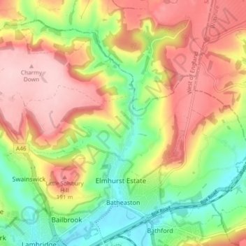
Nome: Mappa topografica Batheaston, altitudine, rilievo.
Altitudine media: 114 m
Altitudine minima: 16 m
Altitudine massima: 213 m
Fai una donazione
Equipaggiati per la tua prossima avventura:
In qualità di Affiliato Amazon, questo sito riceve una commissione sugli acquisti idonei, senza costi aggiuntivi per l’utente.
Altre mappe topografiche
Clicca su una mappa per visualizzarne la topografia, l'altitudine e il rilievo.
Bathwick Hill
United Kingdom > England > Bath and North East Somerset > Bath
Number 1 (Bathwick Lodge) is a 2-storey villa with a steep Mansard room, built in 1825, extended in 1840 and the late C19. Probably by John Pinch the Elder.[4] Number 2 is from the early 19th century and has shutters over the windows.[11] Number 3 includes a porch which is elaborately enriched with carving,…
Altitudine media: 93 m
Hallatrow
United Kingdom > England > Bath and North East Somerset > High Littleton
Altitudine media: 119 m
Norton Hawkfield
United Kingdom > England > Bath and North East Somerset > Norton Malreward
Altitudine media: 96 m
Fai una donazione
Equipaggiati per la tua prossima avventura:
In qualità di Affiliato Amazon, questo sito riceve una commissione sugli acquisti idonei, senza costi aggiuntivi per l’utente.
Knowle Hill
United Kingdom > England > Bath and North East Somerset > Chew Magna
Altitudine media: 65 m
Little Solsbury Hill
United Kingdom > England > Bath and North East Somerset > Batheaston
Altitudine media: 88 m
Monger
United Kingdom > England > Bath and North East Somerset > Midsomer Norton
Altitudine media: 118 m
Fai una donazione
Equipaggiati per la tua prossima avventura:
In qualità di Affiliato Amazon, questo sito riceve una commissione sugli acquisti idonei, senza costi aggiuntivi per l’utente.
Chewton Keynsham
United Kingdom > England > Bath and North East Somerset > Compton Dando
Altitudine media: 57 m
North Wick
United Kingdom > England > Bath and North East Somerset > Chew Magna
Altitudine media: 110 m
Carlingcott
United Kingdom > England > Bath and North East Somerset > Peasedown St. John
Altitudine media: 123 m
Fai una donazione
Equipaggiati per la tua prossima avventura:
In qualità di Affiliato Amazon, questo sito riceve una commissione sugli acquisti idonei, senza costi aggiuntivi per l’utente.
Pipehouse
United Kingdom > England > Bath and North East Somerset > Hinton Charterhouse
Altitudine media: 94 m
Fai una donazione
Equipaggiati per la tua prossima avventura:
In qualità di Affiliato Amazon, questo sito riceve una commissione sugli acquisti idonei, senza costi aggiuntivi per l’utente.
Keynsham Memorial Park
United Kingdom > England > Bath and North East Somerset > Keynsham
Altitudine media: 29 m
Stoney Littleton
United Kingdom > England > Bath and North East Somerset > Shoscombe
Altitudine media: 116 m
Fai una donazione
Equipaggiati per la tua prossima avventura:
In qualità di Affiliato Amazon, questo sito riceve una commissione sugli acquisti idonei, senza costi aggiuntivi per l’utente.
Clutton Hill
United Kingdom > England > Bath and North East Somerset > Farmborough
Altitudine media: 133 m
Fai una donazione
Equipaggiati per la tua prossima avventura:
In qualità di Affiliato Amazon, questo sito riceve una commissione sugli acquisti idonei, senza costi aggiuntivi per l’utente.
Park Corner
United Kingdom > England > Bath and North East Somerset > Freshford > Park Corner
Altitudine media: 93 m
Wick Green
United Kingdom > England > Bath and North East Somerset > Bishop Sutton
Altitudine media: 82 m
Fai una donazione
Equipaggiati per la tua prossima avventura:
In qualità di Affiliato Amazon, questo sito riceve una commissione sugli acquisti idonei, senza costi aggiuntivi per l’utente.
Maes Knoll
United Kingdom > England > Bath and North East Somerset > Norton Malreward
Altitudine media: 110 m
Whitley Batts
United Kingdom > England > Bath and North East Somerset > Pensford
Altitudine media: 87 m
Fai una donazione
Equipaggiati per la tua prossima avventura:
In qualità di Affiliato Amazon, questo sito riceve una commissione sugli acquisti idonei, senza costi aggiuntivi per l’utente.