
Mappa topografica Stowey
Clicca sulla mappa per visualizzare l'altitudine.
A proposito di questa mappa
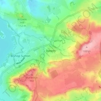
Nome: Mappa topografica Stowey, altitudine, rilievo.
Altitudine media: 109 m
Altitudine minima: 48 m
Altitudine massima: 190 m
Altre mappe topografiche
Clicca su una mappa per visualizzarne la topografia, l'altitudine e il rilievo.
Bath
United Kingdom > England > Bath and North East Somerset
Bath is in the Avon Valley and is surrounded by limestone hills as it is near the southern edge of the Cotswolds, a designated Area of Outstanding Natural Beauty, and the limestone Mendip Hills rise around 7 miles (11 km) south of the city. The hills that surround and make up the city have a maximum altitude…
Altitudine media: 100 m
Chew Valley Lake
United Kingdom > England > Bath and North East Somerset > Compton Martin
Altitudine media: 67 m
Charlcombe
United Kingdom > England > Bath and North East Somerset
The local geology of the Swainswick valley around Sopers Wood, in the south Cotswolds, has been investigated because of the presence of landslides since the work of William Smith in 1799. These are caused by the over-steepened topography downslope of the cap rock formed by the Great Oolite where water egresses…
Altitudine media: 131 m
River Chew
United Kingdom > England > Bath and North East Somerset > Compton Dando
Altitudine media: 76 m
Keynsham Memorial Park
United Kingdom > England > Bath and North East Somerset > Keynsham
Altitudine media: 29 m
North East Somerset and Hanham
United Kingdom > England > Bath and North East Somerset > Compton Dando
Altitudine media: 97 m
Bath
United Kingdom > England > Bath and North East Somerset
The floodplain of the Avon has an altitude of about 59 ft (18 m) above sea level, although the city centre is at an elevation of around 25 metres (82 ft) above sea level. The river, once an unnavigable series of braided streams broken up by swamps and ponds, has been managed by weirs into a single channel.…
Altitudine media: 100 m
Bath
United Kingdom > England > Bath and North East Somerset
Bath is in the Avon Valley and is surrounded by limestone hills as it is near the southern edge of the Cotswolds, a designated Area of Outstanding Natural Beauty, and the Mendip Hills rise around 7 miles (11 km) south of the city. The hills that surround and make up the city have a maximum altitude of 781 feet…
Altitudine media: 100 m
Bath
United Kingdom > England > Bath and North East Somerset
Bath is in the Avon Valley and is surrounded by limestone hills as it is near the southern edge of the Cotswolds, a designated Area of Outstanding Natural Beauty, and the limestone Mendip Hills rise around 7 miles (11 km) south of the city. The hills that surround and make up the city have a maximum altitude…
Altitudine media: 100 m
Bath
United Kingdom > England > Bath and North East Somerset
Bath is in the Avon Valley and is surrounded by limestone hills as it is near the southern edge of the Cotswolds, a designated Area of Outstanding Natural Beauty, and the Mendip Hills rise around 7 miles (11 km) south of the city. The hills that surround and make up the city have a maximum altitude of 781 feet…
Altitudine media: 100 m
Bath
United Kingdom > England > Bath and North East Somerset
Bath is in the Avon Valley and is surrounded by limestone hills as it is near the southern edge of the Cotswolds, a designated Area of Outstanding Natural Beauty, and the Mendip Hills rise around 7 miles (11 km) south of the city. The hills that surround and make up the city have a maximum altitude of 781 feet…
Altitudine media: 100 m