
Mappa topografica Azhikode
Clicca sulla mappa per visualizzare l'altitudine.
A proposito di questa mappa
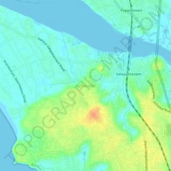
Nome: Mappa topografica Azhikode, altitudine, rilievo.
Luogo: Azhikode, Kannur, Kannur District, Kerala, 670009, India (11.90356 75.31607 11.94356 75.35607)
Altitudine media: 12 m
Altitudine minima: -2 m
Altitudine massima: 40 m
Altre mappe topografiche
Clicca su una mappa per visualizzarne la topografia, l'altitudine e il rilievo.
Kannur
Kannur has an elevation of 1.02 metres or 3.3 feet along the coast of the Laccadive Sea, with a sandy coastal area. The city has an 8 kilometres (5.0 mi)-long seashore and a 3 kilometres (1.9 mi)-long beach at Payyambalam. Kannur is located north of Kozhikode, south of Kasargod and Mangalore, west of the…
Altitudine media: 14 m