
Mappa topografica Mica Peak
Mappa interattiva
Clicca sulla mappa per visualizzare l'altitudine.
A proposito di questa mappa
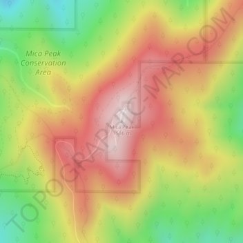
Nome: Mappa topografica Mica Peak, altitudine, rilievo.
Luogo: Mica Peak, Spokane County, Washington, United States (47.57335 -117.08174 47.57345 -117.08164)
Altitudine media: 1’311 m
Altitudine minima: 990 m
Altitudine massima: 1’583 m
Mica Peak is the name of two separate mountain summits in the United States located approximately 5.49 miles (9 km) apart; one in Spokane County, Washington and the other in Kootenai County, Idaho. The two peaks are located along the same ridge, which separates the Spokane Valley and Rathdrum Prairie from the Palouse. The mountains have an elevation difference of only 31 ft (9.4 m) and are the southernmost peaks of the Selkirk Mountains.
Altre mappe topografiche
Clicca su una mappa per visualizzarne la topografia, l'altitudine e il rilievo.
Spokane
United States > Washington > Spokane County
Spokane, Spokane County, Washington, United States
Altitudine media: 655 m
Spokane Valley
United States > Washington > Spokane County
Spokane Valley, Spokane County, Washington, United States
Altitudine media: 673 m
Hampton Bay
United States > Washington > Spokane County
Hampton Bay, Spokane County, Washington, United States
Altitudine media: 666 m
Nine Mile Falls
United States > Washington > Spokane County
Nine Mile Falls, Spokane County, Washington, 99026, United States
Altitudine media: 536 m
Otis Orchards-East Farms
United States > Washington > Spokane County
Otis Orchards-East Farms, Spokane County, Washington, United States
Altitudine media: 668 m
Mount Spokane State Park
United States > Washington > Spokane County
Mount Spokane State Park, Spokane County, Washington, United States
Altitudine media: 976 m
Country Homes
United States > Washington > Spokane County
Country Homes, Spokane County, Washington, 99251, United States
Altitudine media: 599 m
Mead
United States > Washington > Spokane County
Mead, Spokane County, Washington, 99021, United States
Altitudine media: 585 m
Mica
United States > Washington > Spokane County
Mica, Spokane County, Washington, 99023, United States
Altitudine media: 772 m
East Spokane
United States > Washington > Spokane County > Spokane Valley > East Spokane
East Spokane, Spokane Valley, Spokane County, Washington, 99260, United States
Altitudine media: 625 m
Riverfront Park
United States > Washington > Spokane County > Spokane
Riverfront Park, Spokane, Spokane County, Washington, United States
Altitudine media: 583 m
Beacon Hill
United States > Washington > Spokane County
Beacon Hill, Spokane County, Washington, 99211, United States
Altitudine media: 659 m
Orchard Prairie
United States > Washington > Spokane County
Orchard Prairie, Spokane County, Washington, United States
Altitudine media: 682 m