
Fai una donazione
Equipaggiati per la tua prossima avventura:
In qualità di Affiliato Amazon, questo sito riceve una commissione sugli acquisti idonei, senza costi aggiuntivi per l’utente.
Mappa topografica Spokane
Clicca sulla mappa per visualizzare l'altitudine.
Fai una donazione
Equipaggiati per la tua prossima avventura:
In qualità di Affiliato Amazon, questo sito riceve una commissione sugli acquisti idonei, senza costi aggiuntivi per l’utente.
Spokane
Spokane is located on the Spokane River in eastern Washington at an elevation of 1,843 feet (562 m) above sea level, about 18 miles (29 km) from Idaho, 92 miles (148 km) south of the Canadian border, 229 miles (369 km) due east of Seattle, and 279 miles (449 km) southwest of Calgary. The lowest elevation in the city of Spokane is the northernmost point of the Spokane River within city limits (in Riverside State Park) at 1,608 feet (490 m); the highest elevation is on the northeast side, near the community of Hillyard (though closer to Beacon Hill and the North Hill Reservoir) at 2,591 feet (790 m). Spokane is part of the Inland Northwest region, consisting of eastern Washington, north Idaho, northwestern Montana, and northeastern Oregon. The city has a total area of 60.02 square miles (155.45 km2), of which 59.25 square miles (153.46 km2) is land and 0.77 square miles (1.99 km2) is water.
Fai una donazione
Equipaggiati per la tua prossima avventura:
In qualità di Affiliato Amazon, questo sito riceve una commissione sugli acquisti idonei, senza costi aggiuntivi per l’utente.
A proposito di questa mappa
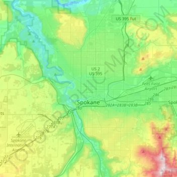
Nome: Mappa topografica Spokane, altitudine, rilievo.
Luogo: Spokane, Spokane County, Washington, United States (47.58678 -117.60400 47.75880 -117.30386)
Altitudine media: 655 m
Altitudine minima: 470 m
Altitudine massima: 1’116 m
Fai una donazione
Equipaggiati per la tua prossima avventura:
In qualità di Affiliato Amazon, questo sito riceve una commissione sugli acquisti idonei, senza costi aggiuntivi per l’utente.
Altre mappe topografiche
Clicca su una mappa per visualizzarne la topografia, l'altitudine e il rilievo.
Mica Peak
United States > Washington > Spokane County
Mica Peak is the name of two separate mountain summits in the United States located approximately 5.49 miles (9 km) apart; one in Spokane County, Washington and the other in Kootenai County, Idaho. The two peaks are located along the same ridge, which separates the Spokane Valley and Rathdrum Prairie from the…
Altitudine media: 1’311 m
Fai una donazione
Equipaggiati per la tua prossima avventura:
In qualità di Affiliato Amazon, questo sito riceve una commissione sugli acquisti idonei, senza costi aggiuntivi per l’utente.
Fai una donazione
Equipaggiati per la tua prossima avventura:
In qualità di Affiliato Amazon, questo sito riceve una commissione sugli acquisti idonei, senza costi aggiuntivi per l’utente.
Fai una donazione
Equipaggiati per la tua prossima avventura:
In qualità di Affiliato Amazon, questo sito riceve una commissione sugli acquisti idonei, senza costi aggiuntivi per l’utente.
Fai una donazione
Equipaggiati per la tua prossima avventura:
In qualità di Affiliato Amazon, questo sito riceve una commissione sugli acquisti idonei, senza costi aggiuntivi per l’utente.
Mica Peak
United States > Washington > Spokane County
Mica Peak is the name of two separate mountain summits in the United States located approximately 5.49 miles (9 km) apart; one in Spokane County, Washington and the other in Kootenai County, Idaho. The two peaks are located along the same ridge, which separates the Spokane Valley and Rathdrum Prairie from the…
Altitudine media: 1’311 m
East Spokane
United States > Washington > Spokane County > Spokane Valley > East Spokane
Altitudine media: 625 m
Fai una donazione
Equipaggiati per la tua prossima avventura:
In qualità di Affiliato Amazon, questo sito riceve una commissione sugli acquisti idonei, senza costi aggiuntivi per l’utente.