
Fai una donazione
Equipaggiati per la tua prossima avventura:
In qualità di Affiliato Amazon, questo sito riceve una commissione sugli acquisti idonei, senza costi aggiuntivi per l’utente.
Mappa topografica Boone
Clicca sulla mappa per visualizzare l'altitudine.
Fai una donazione
Equipaggiati per la tua prossima avventura:
In qualità di Affiliato Amazon, questo sito riceve una commissione sugli acquisti idonei, senza costi aggiuntivi per l’utente.
Boone
Boone has an elevation of 3,333 feet (1,016 m) above sea level. An earlier survey gave the elevation as 3,332 ft and since then it has been published as 3,333 ft (1,016 m). Boone has the highest elevation of any town of its size (over 10,000 population) east of the Mississippi River. As such, Boone features, depending on the isotherm used, a warm-summer humid continental climate (Köppen Dfb), a rarity for the Southeastern United States, bordering on an oceanic climate (Cfb) and straddles the boundary between USDA Plant Hardiness Zones 6B and 7A; the elevation also results in enhanced precipitation, with 59.13 inches (1,500 mm) of average annual precipitation. Compared to the lower elevations of the Carolinas, winters are long and cold, with frequent sleet and snowfall. The daily average temperature in January is 31.5 °F (−0.3 °C), which gives Boone a winter climate more similar to coastal southern New England rather than the Southeast, where a humid subtropical climate (Cfa) predominates. Blizzard-like conditions are not unusual during winters. Summers are warm, but far cooler and less humid than lower regions to the south and east, with a July daily average temperature of 68.4 °F (20.2 °C). Boone receives on average nearly 25 inches (64 cm) of snowfall annually, far higher than the lowland areas in the rest of North Carolina. On January 21, 1985, the temperature fell to −24 °F (−31 °C).
Fai una donazione
Equipaggiati per la tua prossima avventura:
In qualità di Affiliato Amazon, questo sito riceve una commissione sugli acquisti idonei, senza costi aggiuntivi per l’utente.
A proposito di questa mappa
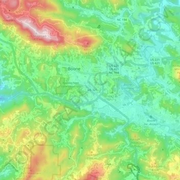
Nome: Mappa topografica Boone, altitudine, rilievo.
Luogo: Boone, Watauga County, North Carolina, United States (36.18640 -81.71645 36.23035 -81.61028)
Altitudine media: 1’069 m
Altitudine minima: 862 m
Altitudine massima: 1’438 m
Fai una donazione
Equipaggiati per la tua prossima avventura:
In qualità di Affiliato Amazon, questo sito riceve una commissione sugli acquisti idonei, senza costi aggiuntivi per l’utente.
Altre mappe topografiche
Clicca su una mappa per visualizzarne la topografia, l'altitudine e il rilievo.
Valle Crucis
United States > North Carolina > Watauga County
Valle Crucis is located at the banks of Dutch Creek and Watauga River, at an elevation of 2,677 feet (816 m) above sea level. To its north and east is Tester Mountain and to its south and west is Valle Mountain. The community is also within the Pisgah National Forest boundary, which limits some development in…
Altitudine media: 904 m
Fai una donazione
Equipaggiati per la tua prossima avventura:
In qualità di Affiliato Amazon, questo sito riceve una commissione sugli acquisti idonei, senza costi aggiuntivi per l’utente.
Fai una donazione
Equipaggiati per la tua prossima avventura:
In qualità di Affiliato Amazon, questo sito riceve una commissione sugli acquisti idonei, senza costi aggiuntivi per l’utente.
Rich Mountain
United States > North Carolina > Watauga County
Rich Mountain is a mountain located in the North Carolina High Country, roughly 3 miles (4.8 km) northwest of the town of Boone. Its elevation reaches 4,748 feet (1,447 m).
Altitudine media: 1’214 m
Buckeye Lake
United States > North Carolina > Watauga County > Beech Mountain
Altitudine media: 1’160 m
Elk Knob
United States > North Carolina > Watauga County
Elk Knob is a mountain in the North Carolina High Country, north of the community of Meat Camp. Its elevation reaches 5,538 feet (1,688 m).
Altitudine media: 1’362 m
Fai una donazione
Equipaggiati per la tua prossima avventura:
In qualità di Affiliato Amazon, questo sito riceve una commissione sugli acquisti idonei, senza costi aggiuntivi per l’utente.
Fai una donazione
Equipaggiati per la tua prossima avventura:
In qualità di Affiliato Amazon, questo sito riceve una commissione sugli acquisti idonei, senza costi aggiuntivi per l’utente.
Rich Mountain
United States > North Carolina > Watauga County
Rich Mountain is a mountain located in the North Carolina High Country, roughly 3 miles (4.8 km) northwest of the town of Boone. Its elevation reaches 4,748 feet (1,447 m).
Altitudine media: 1’214 m
Fai una donazione
Equipaggiati per la tua prossima avventura:
In qualità di Affiliato Amazon, questo sito riceve una commissione sugli acquisti idonei, senza costi aggiuntivi per l’utente.
Appalachian Ski Mountain Dam
United States > North Carolina > Watauga County
Altitudine media: 1’113 m
Boone
United States > North Carolina > Watauga County > Boone > Boone
Boone is located at 36°12′41″N 81°40′7″W / 36.21139°N 81.66861°W / 36.21139; -81.66861 (36.211364, −81.668657) and has an elevation of 3,333 feet (1015.9 m) above sea level. An earlier survey gave the elevation as 3,332 ft and since then it has been published as having an elevation of…
Altitudine media: 977 m
Fai una donazione
Equipaggiati per la tua prossima avventura:
In qualità di Affiliato Amazon, questo sito riceve una commissione sugli acquisti idonei, senza costi aggiuntivi per l’utente.
Sorrento Skies
United States > North Carolina > Watauga County > Sorrento Skies
Altitudine media: 1’069 m
Fai una donazione
Equipaggiati per la tua prossima avventura:
In qualità di Affiliato Amazon, questo sito riceve una commissione sugli acquisti idonei, senza costi aggiuntivi per l’utente.