
Fai una donazione
Equipaggiati per la tua prossima avventura:
In qualità di Affiliato Amazon, questo sito riceve una commissione sugli acquisti idonei, senza costi aggiuntivi per l’utente.
Mappa topografica Foscoe
Clicca sulla mappa per visualizzare l'altitudine.
Fai una donazione
Equipaggiati per la tua prossima avventura:
In qualità di Affiliato Amazon, questo sito riceve una commissione sugli acquisti idonei, senza costi aggiuntivi per l’utente.
A proposito di questa mappa
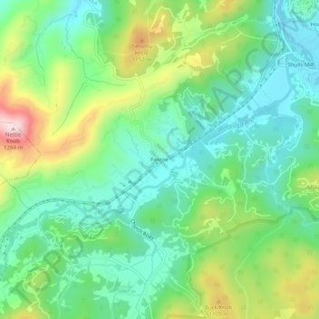
Nome: Mappa topografica Foscoe, altitudine, rilievo.
Luogo: Foscoe, Watauga County, North Carolina, United States (36.14180 -81.78566 36.18180 -81.74566)
Altitudine media: 998 m
Altitudine minima: 876 m
Altitudine massima: 1’258 m
Fai una donazione
Equipaggiati per la tua prossima avventura:
In qualità di Affiliato Amazon, questo sito riceve una commissione sugli acquisti idonei, senza costi aggiuntivi per l’utente.
Altre mappe topografiche
Clicca su una mappa per visualizzarne la topografia, l'altitudine e il rilievo.
Boone
United States > North Carolina > Watauga County
Boone, located in Watauga County, North Carolina, is set within the rugged Appalachian Mountains, specifically the Blue Ridge range. With an elevation of approximately 3,300 feet (1,016 meters), it stands as one of the highest towns of its size in the eastern United States. The terrain is dominated by steep…
Altitudine media: 1’069 m
Beech Mountain
United States > North Carolina > Watauga County
Beech Mountain is a town in both Avery and Watauga counties in the U.S. state of North Carolina. As of the 2010 census, the town population was 320. The town is located atop Beech Mountain and is the highest town east of the Rocky Mountains at 5,506 ft (1,678 m) in elevation. The nearest municipality at a…
Altitudine media: 1’267 m
Blue Ridge Parkway
United States > North Carolina > Watauga County
The parkway has been the most visited unit of the National Park System every year since 1946 except four (1949, 2013, 2016 and 2019). Land on either side of the road is owned and maintained by the National Park Service, and in many places parkway land is bordered by United States Forest Service property. There…
Altitudine media: 504 m
Boone
United States > North Carolina > Watauga County
Boone is located at 36°12′41″N 81°40′7″W / 36.21139°N 81.66861°W / 36.21139; -81.66861 (36.211364, −81.668657) and has an elevation of 3,333 feet (1015.9 m) above sea level. An earlier survey gave the elevation as 3,332 ft and since then it has been published as having an elevation of…
Altitudine media: 1’069 m
Fai una donazione
Equipaggiati per la tua prossima avventura:
In qualità di Affiliato Amazon, questo sito riceve una commissione sugli acquisti idonei, senza costi aggiuntivi per l’utente.
Blowing Rock
United States > North Carolina > Watauga County
Blowing Rock is characterized by its rugged and varied topography, nestled within the southern reaches of the Blue Ridge Mountains. The town itself is situated on a prominent ridge, with elevations ranging from approximately 3,300 to 3,600 feet, creating dramatic landscapes that feature steep slopes, rocky…
Altitudine media: 1’032 m
Blue Ridge Parkway
United States > North Carolina > Watauga County
The parkway has been the most visited unit of the National Park System every year since 1946 except four (1949, 2013, 2016 and 2019).[4][5] Land on either side of the road is owned and maintained by the National Park Service, and in many places parkway land is bordered by United States Forest Service property.…
Altitudine media: 504 m
Buckeye Lake
United States > North Carolina > Watauga County > Beech Mountain
Altitudine media: 1’160 m
Fai una donazione
Equipaggiati per la tua prossima avventura:
In qualità di Affiliato Amazon, questo sito riceve una commissione sugli acquisti idonei, senza costi aggiuntivi per l’utente.
Boone
United States > North Carolina > Watauga County
Boone has an elevation of 3,333 feet (1,016 m) above sea level. An earlier survey gave the elevation as 3,332 ft and since then it has been published as 3,333 ft (1,016 m). Boone has the highest elevation of any town of its size (over 10,000 population) east of the Mississippi River. As such, Boone features,…
Altitudine media: 1’069 m
Blowing Rock
United States > North Carolina > Watauga County
The climate in the area can be described as warm-summer humid continental (Dfb), or highland subtropical climate (Cfb) depending on the isotherm used; Köppen Climate Classification. This results in an unusual climate compared to the rest of North Carolina; the town's elevation of 3,500 to 3,600 feet (1,100 to…
Altitudine media: 1’032 m
Fai una donazione
Equipaggiati per la tua prossima avventura:
In qualità di Affiliato Amazon, questo sito riceve una commissione sugli acquisti idonei, senza costi aggiuntivi per l’utente.
Blowing Rock
United States > North Carolina > Watauga County
The climate in the area can be described as warm-summer humid continental (Dfb), or highland subtropical climate (Cfb) depending on the isotherm used; Köppen Climate Classification. This results in an unusual climate compared to the rest of North Carolina; the town's elevation of 3,500 to 3,600 feet (1,100 to…
Altitudine media: 1’032 m
Moses H Cone Memorial Park
United States > North Carolina > Watauga County > Blowing Rock
Altitudine media: 1’121 m
Boone
United States > North Carolina > Watauga County
Boone is located at 36°12′41″N 81°40′7″W / 36.21139°N 81.66861°W / 36.21139; -81.66861 (36.211364, −81.668657) and has an elevation of 3,333 feet (1015.9 m) above sea level. An earlier survey gave the elevation as 3,332 ft and since then it has been published as having an elevation of…
Altitudine media: 1’069 m