
Mappa topografica Kerala
Clicca sulla mappa per visualizzare l'altitudine.
Kerala
The state is wedged between the Laccadive Sea and the Western Ghats. Lying between northern latitudes 8°18' and 12°48' and eastern longitudes 74°52' and 77°22', Kerala experiences humid tropical rainforest climate with some cyclones. The state has a coast of 590 km (370 mi) and the width of the state varies between 11 and 121 kilometres (7 and 75 mi). Geographically, Kerala can be divided into three climatically distinct regions: the eastern highlands; rugged and cool mountainous terrain, the central mid-lands; rolling hills, and the western lowlands; coastal plains. Pre-Cambrian and Pleistocene geological formations compose the bulk of Kerala's terrain. A catastrophic flood in Kerala in 1341 CE drastically modified its terrain and consequently affected its history; it also created a natural harbour for spice transport. The eastern region of Kerala consists of high mountains, gorges and deep-cut valleys immediately west of the Western Ghats' rain shadow. 41 of Kerala's west-flowing rivers, and 3 of its east-flowing ones originate in this region. The Western Ghats form a wall of mountains interrupted only near Palakkad; hence also known Palghat, where the Palakkad Gap breaks. The Western Ghats rise on average to 1,500 metres (4,900 feet) above sea level, while the highest peaks reach around 2,500 metres (8,200 feet). Anamudi in the Idukki district is the highest peak in south India, is at an elevation of 2,695 m (8,842 ft). The Western Ghats mountain chain is recognised as one of the world's eight "hottest hotspots" of biological diversity and is listed among UNESCO World Heritage Sites. The chain's forests are considered to be older than the Himalaya mountains. The Athirappilly Falls, which is situated on the background of Western Ghat mountain ranges, is also known as The Niagara of India. It is located in the Chalakudy River and is the largest waterfall in the state. Wayanad is the sole Plateau in Kerala. The eastern regions in the districts of Wayanad, Malappuram (Chaliyar valley at Nilambur), and Palakkad (Attappadi Valley), which together form parts of the Nilgiri Biosphere Reserve and a continuation of the Mysore Plateau, are known for natural Gold fields, along with the adjoining districts of Karnataka. Minerals including Ilmenite, Monazite, Thorium, and Titanium, are found in the coastal belt of Kerala. Kerala's coastal belt of Karunagappally is known for high background radiation from thorium-containing monazite sand. In some coastal panchayats, median outdoor radiation levels are more than 4 mGy/yr and, in certain locations on the coast, it is as high as 70 mGy/yr.
A proposito di questa mappa
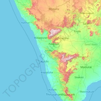
Nome: Mappa topografica Kerala, altitudine, rilievo.
Luogo: Kerala, India (8.29353 74.86407 12.79606 77.41236)
Altitudine media: 251 m
Altitudine minima: -4 m
Altitudine massima: 2’557 m
Altre mappe topografiche
Clicca su una mappa per visualizzarne la topografia, l'altitudine e il rilievo.
Vadodara
India > Gujarat > Vadodara Rural Taluka
Vadodara is located at 22°18′N 73°11′E / 22.30°N 73.19°E / 22.30; 73.19 in western India at an elevation of 39 metres (128 ft). It is the tenth-largest city in India with an area of 400 square kilometres (150 sq mi) and a population of 3.5 million, according to the 2010–11 census. The city…
Altitudine media: 36 m
Ranchi
Ranchi lies at 23°22′N 85°20′E / 23.36°N 85.33°E / 23.36; 85.33 near to the Tropic of Cancer. The city covers an area of 175 km2 (68 sq mi) and its average elevation is 651 m above sea level. Ranchi is located in the southern part of the Chota Nagpur plateau, which is the eastern section of…
Altitudine media: 648 m
Western Ghats
The range starts near south of the Tapti river and runs approximately 1,600 km (990 mi) through the states of Gujarat, Maharashtra, Karnataka, Goa, Kerala and Tamil Nadu ending at Marunthuvazh Malai, Swamithope near the southern tip of India. These hills cover 160,000 km2 (62,000 sq mi) and form the catchment…
Altitudine media: 2’225 m
Srinagar
India > Jammu and Kashmir > Srinagar (South)
Under the Köppen climate classification, Srinagar has a four-season humid subtropical climate (Cfa) with hot summers and cool winters. The valley is surrounded by the Himalayas on all sides. Due to influence from Himalayan rain shadow and western disturbances, Srinagar has year-round precipitation; the spring…
Altitudine media: 1’805 m
Chennai
Chennai is located on the south–eastern coast of India in the north–eastern part of Tamil Nadu on a flat coastal plain known as the Eastern Coastal Plains. Its average elevation is around 6.7 metres (22 ft), and its highest point is 60 m (200 ft). Chennai is 2,184 kilometres (1,357 mi) south of Delhi,…
Altitudine media: 7 m
Maharashtra
Maharashtra is the third largest state by area in India. The Western Ghats better known as Sahyadri, are a hilly range running parallel to the coast, at an average elevation of 1,200 metres (4,000 ft). Kalsubai, a peak in the Sahyadris, near Nashik city is the highest elevated point in Maharashtra. To the west…
Altitudine media: 478 m
Jammu
India > Jammu and Kashmir > Jammu
Jammu is located at 32°44′N 74°52′E / 32.73°N 74.87°E / 32.73; 74.87. It has an average elevation of 300 m (980 ft). Jammu city lies at uneven ridges of low heights at the Shivalik hills. It is surrounded by the Shivalik range to the north, east, and southeast while the Trikuta Range surrounds…
Altitudine media: 367 m
Navi Mumbai
India > Maharashtra > Thane > Navi Mumbai
Navi Mumbai (Marathi pronunciation: , also known by its former name New Bombay), is a planned city off the west coast of the Indian state of Maharashtra in Konkan division. The city is divided into two parts, North Navi Mumbai and South Navi Mumbai, for the individual development of Panvel Mega City, which…
Altitudine media: 30 m
Madurai
India > Tamil Nadu > Madurai
Madurai is located at 9°56′N 78°07′E / 9.93°N 78.12°E / 9.93; 78.12. It has an average elevation of 101 metres. The city of Madurai lies on the flat and fertile plain of the river Vaigai, which runs in the northwest-southeast direction through the city, dividing it into two almost equal…
Altitudine media: 138 m
Mumbai
Mumbai lies at the mouth of the Ulhas River on the western coast of India, in the coastal region known as the Konkan. It sits on Salsette Island (Sashti Island), which it partially shares with the Thane district. Mumbai is bounded by the Arabian Sea to the west. Many parts of the city lie just above sea level,…
Altitudine media: 13 m
Dwarka
India > Gujarat > Okhamandal Taluka
Considered a holy city, Dwarka is well known for its temples and as a pilgrimage centre for Hindus. The Dwarakadhisa Temple, also called Jagat Mandir, located in the heart of Dwarka, is a Vaishnava temple. It was built by Raja Jagat Singh Rathore, hence it is called Jagat Mandir. The temple, facing west, is at…
Altitudine media: 3 m
Cuttack
India > Odisha > Cuttack (M.Corp.) P.S
Cuttack is located at 20°31′23″N 085°47′17″E / 20.52306°N 85.78806°E / 20.52306; 85.78806 and has an average elevation of 36 metres (118 ft). The city is spread across an area of 192.5 km2 (74 sq mi). The city, being a Cuttack Municipal Corporation which consists of 59 wards. The city…
Altitudine media: 34 m
Kakinada
India > Andhra Pradesh > Kakinada Urban
Kakinada is located at 16°56′N 82°13′E / 16.93°N 82.22°E / 16.93; 82.22, with the 82-degrees east longitude passing through the city. The city has an average elevation of 2 meters (6.6 feet), and several areas lie below sea level.
Altitudine media: 7 m
Jaitaran
India > Rajasthan > Jaitaran Tehsil
Jaitaran is located at 26°12′N 73°56′E / 26.2°N 73.94°E / 26.2; 73.94. It has an average elevation of 307metres (1007feet).
Altitudine media: 300 m
Agra
India > Uttar Pradesh > Agra
The region around Agra consists almost entirely of a level plain, with hills in the extreme southwest. The rivers in the region include Yamuna and Chambal. The region is also watered by the Agra Canal. Millet, barley, wheat and cotton are among the crops grown in the surrounding countryside. Both Rabi and…
Altitudine media: 166 m
Chakrata
India > Uttarakhand > Chakrata
It lies between the Tons and Yamuna rivers, at an elevation of 2118 m, 98 km from the state capital, Dehradun. Chakrata was originally a cantonment of the British Indian Army. To the west lies Shillai, Himachal Pradesh, and to the east are Mussoorie (73 km) and Tehri Garhwal.
Altitudine media: 1’851 m
Kadiri
India > Andhra Pradesh > Kadiri
Kadiri is located at 78.170 degrees E longitude and 14.120 degrees N latitude and has an average elevation of 504.00 meters (1653 feet) above MSL. Kadiri is surrounded by hill on the north and east.
Altitudine media: 550 m
Kodaikanal
India > Tamil Nadu > Kodaikanal
Kodaikanal has a monsoon-influenced subtropical highland climate (Cfb, according to the Köppen climate classification, with a Cwb tendency). The temperatures are cool throughout the year due to the high elevation of the city.
Altitudine media: 1’958 m
Palladam
India > Tamil Nadu > Palladam
Palladam is located at 10°59′N 77°18′E / 10.98°N 77.3°E / 10.98; 77.3. It has an average elevation of 325 metres (1,066 feet). Palladam is located near to Tirupur (14 km away) which is called the 'Dollar City' of Tamil Nadu, 15 km from the village of Putharachal and located 38 km east of the…
Altitudine media: 377 m
Aluva
Aluva Railway Station (IR Code: AWY) is a grade-A railway station in Kerala, and is the third busiest railway station in Kochi after Ernakulam Junction railway station and Ernakulam Town railway station. All passenger and express trains bound to southern Kerala have a stop at it. People travelling from the…
Altitudine media: 11 m
Shimla
Shimla is on the south-western ranges of the Himalayas at 31°37′N 77°06′E / 31.61°N 77.10°E / 31.61; 77.10. It has an average altitude of 2,206 metres (7,238 ft) above mean sea level and extends along a ridge with seven spurs. The city stretches nearly 9.2 kilometres (5.7 mi) from east to west.
Altitudine media: 1’557 m
Chengalpattu
India > Tamil Nadu > Chengalpattu
Chengalpattu is located at 12°42′N 79°59′E / 12.7°N 79.98°E / 12.7; 79.98. It has an average elevation of 36 metres (118 ft). Lake Kolavai is the largest located in Chengalpattu.
Altitudine media: 48 m
Badami
India > Karnataka > Badami taluku
Badami is located at 15°55′N 75°41′E / 15.92°N 75.68°E / 15.92; 75.68. It has an average elevation of 586 metres (1922 ft). It is located at the mouth of a ravine between two rocky hills and surrounds Agastya tirtha water reservoir on the three other sides. The total area of the town is 10.3…
Altitudine media: 587 m
Angul
Angul (also known as Anugul) is a town and a municipality and the headquarters of Angul district in the state of Odisha, India. Angul has an average elevation of 195 m (640 ft) above sea level. The total geographical area of the district is 6232 km2. From the point of view of area, it stands 11th among the 30…
Altitudine media: 121 m
Vijayawada
India > Andhra Pradesh > Vijayawada (Urban)
Vijayawada lies on the banks of Krishna river, covered by hills and canals. and at an altitude of 11 m (36 ft) above sea level. Three canals originating from the north side of the Prakasam Barrage reservoir — Eluru, Bandar, and Ryves — flow through the city.
Altitudine media: 37 m
Guwahati
Professor Abani Kumar Bhagawati of Gauhati University stated that since before there were sufficient wetlands to absorb rainwater and channels to carry excess water to the Brahmaputra, the city did not experience floods. However, human interference has disrupted the natural topography, leading to the current…
Altitudine media: 113 m
Dehradun
India > Uttarakhand > Dehradun
The city of Dehradun mainly lies in Doon Valley and is at a varying height from 410 m (1,350 ft) in Clement Town to above 700 m (2,300 ft) at Malsi which is 15 km (9.3 mi) from the city. However, the average elevation is 450 m (1,480 ft) above sea level. Malsi is the starting point of Lesser Himalayan Range…
Altitudine media: 904 m
Ranchi
Ranchi lies at 23°22′N 85°20′E / 23.36°N 85.33°E / 23.36; 85.33 near to the Tropic of Cancer. The city covers an area of 175 km2 (68 sq mi) and its average elevation is 651 m above sea level. Ranchi is located in the southern part of the Chota Nagpur plateau, which is the eastern section of…
Altitudine media: 648 m
Thrissur
Thrissur is the headquarters of Thrissur district, in the centre of the Indian state of Kerala. The city is 75 km north-east of Kochi, 133 km south-west of Coimbatore, 124 km south-east of Kozhikode and 151 km north of Changanacherry. The city is located in a hillock called Thekkinkadu Maidan which is the…
Altitudine media: 36 m
Thiruvananthapuram
India > Kerala > Thiruvananthapuram
Thiruvananthapuram is built on seven hills by the seashore and is at 8°30′N 76°54′E / 8.5°N 76.9°E / 8.5; 76.9 on the west coast, near the southern tip of mainland India. The city is on the west coast of India and is bounded by the Laccadive Sea to its west and the Western Ghats to its east.…
Altitudine media: 33 m
Visakhapatnam
India > Andhra Pradesh > Visakhapatnam Urban
The city is situated between the Eastern Ghats and the Bay of Bengal. The city coordinates lies between 17.7041 N and 83.2977 E. The city's area is 682 km2. The average elevation is 45 metres. Visakhpatnam is situated in Coastal Andhra Region.
Altitudine media: 35 m
Mumbai
Mumbai lies at the mouth of the Ulhas River on the western coast of India, in the coastal region known as the Konkan. It sits on Salsette Island (Sashti Island), which it partially shares with the Thane district. Mumbai is bounded by the Arabian Sea to the west. Many parts of the city lie just above sea level,…
Altitudine media: 13 m
Chakdaha
India > West Bengal > Chakdaha
Chakdaha is a prominent urban local body in the district of Nadia, one of the southern districts of West Bengal. Chakdaha's location is 23°05′N 88°31′E / 23.08°N 88.52°E / 23.08; 88.52. It has an average elevation of 11 meters (36 feet) and is 62 km north of the state capital, Kolkata. It is…
Altitudine media: 10 m