
Mappa topografica Bibury
Clicca sulla mappa per visualizzare l'altitudine.
Bibury
The parish is approximately rectangular and stretches far to the rolling, elevated, north. It includes on outlying settlement, Ablington, in the upper valley. Bibury Farm is 300 metres (330 yd) from the village, 151 metres (495 ft) above Ordnance Datum (AOD), which is a similar elevation to much of the north. The south rises to a maximum of 141 metres (463 ft) on its periphery along Akeman Street, a Roman road, before ascending further in other more distant lands. The valley floor within the Bibury boundary, northwest and southeast, ranges from 108 to 98 metres (354 to 322 ft) AOD.
A proposito di questa mappa
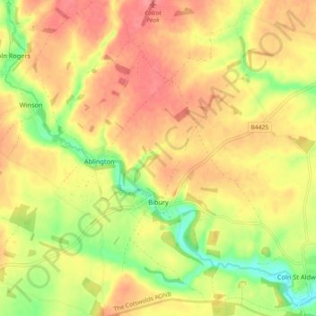
Nome: Mappa topografica Bibury, altitudine, rilievo.
Altitudine media: 135 m
Altitudine minima: 94 m
Altitudine massima: 163 m
Altre mappe topografiche
Clicca su una mappa per visualizzarne la topografia, l'altitudine e il rilievo.
Duntisbourne Abbots
United Kingdom > England > Gloucestershire > Cotswold District
Altitudine media: 204 m
Stow-on-the-Wold
United Kingdom > England > Gloucestershire > Cotswold District
Altitudine media: 163 m
Bushley Muzzard, Brimpsfield
United Kingdom > England > Gloucestershire > Cotswold District > Nettleton > Watercombe
Altitudine media: 261 m
Lower Slaughter
United Kingdom > England > Gloucestershire > Cotswold District
Altitudine media: 160 m
Calcot
United Kingdom > England > Gloucestershire > Cotswold District > Coln Rogers
Altitudine media: 151 m
Caudle Green
United Kingdom > England > Gloucestershire > Cotswold District > Brimpsfield
Altitudine media: 234 m
Bourton-on-the-Hill
United Kingdom > England > Gloucestershire > Cotswold District
Altitudine media: 196 m
Hidcote Bartrim
United Kingdom > England > Gloucestershire > Cotswold District > Ebrington
Altitudine media: 148 m
Knap House Quarry, Birdlip
United Kingdom > England > Gloucestershire > Cotswold District > Birdlip
Altitudine media: 222 m
Botany Bay Wood
United Kingdom > England > Gloucestershire > Cotswold District > Stow-on-the-Wold
Altitudine media: 171 m
Shipton Oliffe
United Kingdom > England > Gloucestershire > Cotswold District > Shipton
Altitudine media: 201 m
Seven Springs
United Kingdom > England > Gloucestershire > Cotswold District > Coberley
Altitudine media: 236 m
Nags Head
United Kingdom > England > Gloucestershire > Cotswold District > Avening
Altitudine media: 155 m
Upper Oddington
United Kingdom > England > Gloucestershire > Cotswold District
Altitudine media: 134 m
Winstone
United Kingdom > England > Gloucestershire > Cotswold District > Winstone
Altitudine media: 222 m
Eastleach Martin
United Kingdom > England > Gloucestershire > Cotswold District > Eastleach Turville
Altitudine media: 111 m
Paxford
United Kingdom > England > Gloucestershire > Cotswold District > Paxford
Altitudine media: 124 m
Somerford Keynes
United Kingdom > England > Gloucestershire > Cotswold District
Altitudine media: 91 m
Bledington
United Kingdom > England > Gloucestershire > Cotswold District > Bledington
Altitudine media: 118 m
Ablington
United Kingdom > England > Gloucestershire > Cotswold District > Ablington
Altitudine media: 136 m