
Fai una donazione
Equipaggiati per la tua prossima avventura:
In qualità di Affiliato Amazon, questo sito riceve una commissione sugli acquisti idonei, senza costi aggiuntivi per l’utente.
Mappa topografica Saintbury
Clicca sulla mappa per visualizzare l'altitudine.
Fai una donazione
Equipaggiati per la tua prossima avventura:
In qualità di Affiliato Amazon, questo sito riceve una commissione sugli acquisti idonei, senza costi aggiuntivi per l’utente.
A proposito di questa mappa
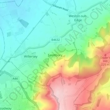
Nome: Mappa topografica Saintbury, altitudine, rilievo.
Altitudine media: 124 m
Altitudine minima: 51 m
Altitudine massima: 272 m
Fai una donazione
Equipaggiati per la tua prossima avventura:
In qualità di Affiliato Amazon, questo sito riceve una commissione sugli acquisti idonei, senza costi aggiuntivi per l’utente.
Altre mappe topografiche
Clicca su una mappa per visualizzarne la topografia, l'altitudine e il rilievo.
Chedworth
United Kingdom > England > Gloucestershire > Cotswold District > Chedworth
Altitudine media: 187 m
Chipping Campden
United Kingdom > England > Gloucestershire > Cotswold District
Altitudine media: 191 m
Worcestershire (detached)
United Kingdom > England > Gloucestershire > Cotswold District
Altitudine media: 103 m
Fai una donazione
Equipaggiati per la tua prossima avventura:
In qualità di Affiliato Amazon, questo sito riceve una commissione sugli acquisti idonei, senza costi aggiuntivi per l’utente.
Cirencester Park
United Kingdom > England > Gloucestershire > Cotswold District > Sapperton
Altitudine media: 162 m
Cold Aston
United Kingdom > England > Gloucestershire > Cotswold District > Cold Aston
Altitudine media: 189 m
Cirencester
United Kingdom > England > Gloucestershire > Cotswold District
On Cotswold Avenue is the site of a Roman amphitheatre which, while buried, retains its shape in the earthen topography of the small park setting. Cirencester was one of the most substantial cities of Roman-era Britain.
Altitudine media: 128 m
Fai una donazione
Equipaggiati per la tua prossima avventura:
In qualità di Affiliato Amazon, questo sito riceve una commissione sugli acquisti idonei, senza costi aggiuntivi per l’utente.
South Cerney
United Kingdom > England > Gloucestershire > Cotswold District > South Cerney
Altitudine media: 93 m
Upper Rissington
United Kingdom > England > Gloucestershire > Cotswold District > Upper Rissington
Altitudine media: 208 m
Fai una donazione
Equipaggiati per la tua prossima avventura:
In qualità di Affiliato Amazon, questo sito riceve una commissione sugli acquisti idonei, senza costi aggiuntivi per l’utente.
Bourton-on-the-Hill
United Kingdom > England > Gloucestershire > Cotswold District
Altitudine media: 200 m
Little Rissington
United Kingdom > England > Gloucestershire > Cotswold District > Little Rissington
Altitudine media: 171 m
Fai una donazione
Equipaggiati per la tua prossima avventura:
In qualità di Affiliato Amazon, questo sito riceve una commissione sugli acquisti idonei, senza costi aggiuntivi per l’utente.
Coberley
United Kingdom > England > Gloucestershire > Cotswold District > Coberley
Altitudine media: 234 m
Bibury
United Kingdom > England > Gloucestershire > Cotswold District
The parish is approximately rectangular and stretches far to the rolling, elevated, north. It includes on outlying settlement, Ablington, in the upper valley. Bibury Farm is 300 metres (330 yd) from the village, 151 metres (495 ft) above Ordnance Datum (AOD), which is a similar elevation to much of the north.…
Altitudine media: 135 m
Fai una donazione
Equipaggiati per la tua prossima avventura:
In qualità di Affiliato Amazon, questo sito riceve una commissione sugli acquisti idonei, senza costi aggiuntivi per l’utente.
Botany Bay Wood
United Kingdom > England > Gloucestershire > Cotswold District > Stow-on-the-Wold
Altitudine media: 171 m
Baunton
United Kingdom > England > Gloucestershire > Cotswold District > Baunton
Altitudine media: 146 m
Fai una donazione
Equipaggiati per la tua prossima avventura:
In qualità di Affiliato Amazon, questo sito riceve una commissione sugli acquisti idonei, senza costi aggiuntivi per l’utente.
Somerford Keynes
United Kingdom > England > Gloucestershire > Cotswold District > Somerford Keynes
Altitudine media: 92 m
Evenlode
United Kingdom > England > Gloucestershire > Cotswold District > Evenlode
Altitudine media: 134 m
Great Rissington
United Kingdom > England > Gloucestershire > Cotswold District > Great Rissington
Altitudine media: 168 m
Fai una donazione
Equipaggiati per la tua prossima avventura:
In qualità di Affiliato Amazon, questo sito riceve una commissione sugli acquisti idonei, senza costi aggiuntivi per l’utente.
Long Newnton
United Kingdom > England > Gloucestershire > Cotswold District > Long Newnton
Altitudine media: 117 m
Bagendon
United Kingdom > England > Gloucestershire > Cotswold District > Bagendon
Altitudine media: 171 m
Didmarton
United Kingdom > England > Gloucestershire > Cotswold District > Didmarton
Altitudine media: 147 m
Fai una donazione
Equipaggiati per la tua prossima avventura:
In qualità di Affiliato Amazon, questo sito riceve una commissione sugli acquisti idonei, senza costi aggiuntivi per l’utente.
Daglingworth
United Kingdom > England > Gloucestershire > Cotswold District > Daglingworth
Altitudine media: 169 m
Fai una donazione
Equipaggiati per la tua prossima avventura:
In qualità di Affiliato Amazon, questo sito riceve una commissione sugli acquisti idonei, senza costi aggiuntivi per l’utente.
Poulton
United Kingdom > England > Gloucestershire > Cotswold District > Poulton
Altitudine media: 109 m
Bourton-on-the-Water
United Kingdom > England > Gloucestershire > Cotswold District
Altitudine media: 155 m
Fai una donazione
Equipaggiati per la tua prossima avventura:
In qualità di Affiliato Amazon, questo sito riceve una commissione sugli acquisti idonei, senza costi aggiuntivi per l’utente.
Winson
United Kingdom > England > Gloucestershire > Cotswold District > Winson
Altitudine media: 145 m
Fai una donazione
Equipaggiati per la tua prossima avventura:
In qualità di Affiliato Amazon, questo sito riceve una commissione sugli acquisti idonei, senza costi aggiuntivi per l’utente.
Windrush
United Kingdom > England > Gloucestershire > Cotswold District > Windrush
Altitudine media: 155 m
Sherborne
United Kingdom > England > Gloucestershire > Cotswold District > Sherborne
Altitudine media: 156 m
Elkstone
United Kingdom > England > Gloucestershire > Cotswold District > Elkstone
Altitudine media: 234 m
Fai una donazione
Equipaggiati per la tua prossima avventura:
In qualità di Affiliato Amazon, questo sito riceve una commissione sugli acquisti idonei, senza costi aggiuntivi per l’utente.
Down Ampney
United Kingdom > England > Gloucestershire > Cotswold District > Down Ampney
Altitudine media: 85 m
Hazleton
United Kingdom > England > Gloucestershire > Cotswold District > Hazleton
Altitudine media: 227 m
Fai una donazione
Equipaggiati per la tua prossima avventura:
In qualità di Affiliato Amazon, questo sito riceve una commissione sugli acquisti idonei, senza costi aggiuntivi per l’utente.
Naunton
United Kingdom > England > Gloucestershire > Cotswold District > Naunton
Altitudine media: 201 m
Fai una donazione
Equipaggiati per la tua prossima avventura:
In qualità di Affiliato Amazon, questo sito riceve una commissione sugli acquisti idonei, senza costi aggiuntivi per l’utente.
Bushley Muzzard, Brimpsfield
United Kingdom > England > Gloucestershire > Cotswold District > Nettleton > Watercombe
Altitudine media: 261 m
Fairford
United Kingdom > England > Gloucestershire > Cotswold District > Fairford
Altitudine media: 98 m
Moreton-in-Marsh
United Kingdom > England > Gloucestershire > Cotswold District
Altitudine media: 135 m
Knap House Quarry, Birdlip
United Kingdom > England > Gloucestershire > Cotswold District > Birdlip
Altitudine media: 222 m
Fai una donazione
Equipaggiati per la tua prossima avventura:
In qualità di Affiliato Amazon, questo sito riceve una commissione sugli acquisti idonei, senza costi aggiuntivi per l’utente.
Fai una donazione
Equipaggiati per la tua prossima avventura:
In qualità di Affiliato Amazon, questo sito riceve una commissione sugli acquisti idonei, senza costi aggiuntivi per l’utente.
Cirencester
United Kingdom > England > Gloucestershire > Cotswold District
On Cotswold Avenue is the site of a Roman amphitheatre which, while buried, retains its shape in the earthen topography of the small park setting. Cirencester was one of the most substantial cities of Roman-era Britain.
Altitudine media: 128 m
Fai una donazione
Equipaggiati per la tua prossima avventura:
In qualità di Affiliato Amazon, questo sito riceve una commissione sugli acquisti idonei, senza costi aggiuntivi per l’utente.
Didmarton
United Kingdom > England > Gloucestershire > Cotswold District > Didmarton
Altitudine media: 147 m
Cirencester
United Kingdom > England > Gloucestershire > Cotswold District > Chesterton
On Cotswold Avenue is the site of a Roman amphitheatre which, while buried, retains its shape in the earthen topography of the small park setting. Cirencester was one of the most substantial cities of Roman-era Britain.
Altitudine media: 128 m
Fai una donazione
Equipaggiati per la tua prossima avventura:
In qualità di Affiliato Amazon, questo sito riceve una commissione sugli acquisti idonei, senza costi aggiuntivi per l’utente.
Chipping Campden
United Kingdom > England > Gloucestershire > Cotswold District
Altitudine media: 191 m
Cirencester
United Kingdom > England > Gloucestershire > Cotswold District > Chesterton
On Cotswold Avenue is the site of a Roman amphitheatre which, while buried, retains its shape in the earthen topography of the small park setting. Cirencester was one of the most substantial cities of Roman-era Britain.
Altitudine media: 128 m