
Mappa topografica Huntingdonshire
Clicca sulla mappa per visualizzare l'altitudine.
A proposito di questa mappa
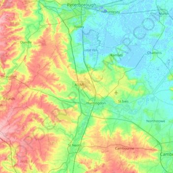
Nome: Mappa topografica Huntingdonshire, altitudine, rilievo.
Altitudine media: 32 m
Altitudine minima: -19 m
Altitudine massima: 103 m
Altre mappe topografiche
Clicca su una mappa per visualizzarne la topografia, l'altitudine e il rilievo.
Peterborough
United Kingdom > England > Cambridgeshire
The local topography is flat, and in some places, the land lies below sea level, for example in parts of the Fens to the east and to the south of Peterborough. Human settlement in the area began before the Bronze Age, as can be seen at the Flag Fen archaeological site to the east of the current city centre,…
Altitudine media: 17 m
Great Chishill
United Kingdom > England > Cambridgeshire > South Cambridgeshire
Altitudine media: 112 m
Wardy Hill
United Kingdom > England > Cambridgeshire > East Cambridgeshire > Coveney
Altitudine media: 4 m
River Great Ouse or Ely Ouse
United Kingdom > England > Cambridgeshire > East Cambridgeshire > Soham > Stuntney
Altitudine media: 4 m
Holme Fen
United Kingdom > England > Cambridgeshire > East Cambridgeshire > Haddenham
Altitudine media: 4 m
Little Ouse
United Kingdom > England > Cambridgeshire > East Cambridgeshire > Littleport
Altitudine media: -1 m
Green End
United Kingdom > England > Cambridgeshire > Huntingdonshire > Great Stukeley
Altitudine media: 32 m
Hinchingbrooke Country Park
United Kingdom > England > Cambridgeshire > Huntingdonshire > Huntingdon > Brampton
Altitudine media: 16 m
Cambridge
United Kingdom > England > Cambridgeshire
The city, like most of the UK, has a maritime climate highly influenced by the Gulf Stream. Located in the driest region of Britain, Cambridge's rainfall averages around 570 mm (22.44 in) per year, around half the national average, The driest recent year was in 2011 with 380.4 mm (14.98 in) of rain at the…
Altitudine media: 33 m
Chittering
United Kingdom > England > Cambridgeshire > South Cambridgeshire > Waterbeach
Altitudine media: 3 m
Eastrea
United Kingdom > England > Cambridgeshire > Fenland District > Whittlesey > Coates
Altitudine media: 3 m
Huntingdon Castle
United Kingdom > England > Cambridgeshire > Huntingdonshire > Huntingdon > Hartford
Altitudine media: 14 m
Odsey
United Kingdom > England > Cambridgeshire > South Cambridgeshire > Steeple Morden
Altitudine media: 82 m
Rack Fen
United Kingdom > England > Cambridgeshire > East Cambridgeshire > Littleport
Altitudine media: 0 m
Washingley
United Kingdom > England > Cambridgeshire > Huntingdonshire > Folksworth
Altitudine media: 48 m
Nine Wells
United Kingdom > England > Cambridgeshire > South Cambridgeshire > Great Shelford
Altitudine media: 20 m
Bourn Bridge
United Kingdom > England > Cambridgeshire > South Cambridgeshire > Little Abington
Altitudine media: 39 m
Chippenham Fen NNR (permit access)
United Kingdom > England > Cambridgeshire > East Cambridgeshire
Altitudine media: 17 m
Westwick
United Kingdom > England > Cambridgeshire > South Cambridgeshire > Oakington > Westwick
Altitudine media: 11 m
Little Linton
United Kingdom > England > Cambridgeshire > South Cambridgeshire > Linton
Altitudine media: 62 m
Hartford Marina
United Kingdom > England > Cambridgeshire > Huntingdonshire > Wyton
Altitudine media: 14 m
Hatley's Children's Pit
United Kingdom > England > Cambridgeshire > South Cambridgeshire > Landbeach
Altitudine media: 7 m
Wisbech and Upwell Tramway
United Kingdom > England > Cambridgeshire > Fenland > Friday Bridge
Altitudine media: 3 m
Gamlingay Wood NR
United Kingdom > England > Cambridgeshire > South Cambridgeshire > Gamlingay
Altitudine media: 56 m
Hayley Wood NR
United Kingdom > England > Cambridgeshire > South Cambridgeshire > Hatley
Altitudine media: 76 m
Mill Pool
United Kingdom > England > Cambridgeshire > Huntingdonshire > Huntingdon
Altitudine media: 14 m
Peterborough
United Kingdom > England > Cambridgeshire
The city is 74 miles (119 km) north of London, on the River Nene which flows into The Wash 27 miles (43 km) to the north-east; the cathedral city of Ely is 24 miles (39 km) east-southeast across the Fens and the university city of Cambridge is 30 miles (48 km) to the southeast. The local topography is flat,…
Altitudine media: 17 m
Peterborough
United Kingdom > England > Cambridgeshire
The cathedral city of Ely is 24 miles (39 km) east-southeast across the Fens and the university city of Cambridge is 30 miles (48 km) to the southeast. The local topography is flat, and in places, the land lies below sea level.
Altitudine media: 17 m
Peterborough
United Kingdom > England > Cambridgeshire
The local topography is flat, and in some places, the land lies below sea level, for example in parts of the Fens to the east and to the south of Peterborough. Human settlement in the area began before the Bronze Age, as can be seen at the Flag Fen archaeological site to the east of the current city centre,…
Altitudine media: 17 m
Witcham Toll
United Kingdom > England > Cambridgeshire > East Cambridgeshire > Witcham
Altitudine media: 10 m
Peterborough
United Kingdom > England > Cambridgeshire
The city is 74 miles (119 km) north of London, on the River Nene which flows into The Wash 27 miles (43 km) to the north-east; the cathedral city of Ely is 24 miles (39 km) east-southeast across the Fens and the university city of Cambridge is 30 miles (48 km) to the southeast. The local topography is flat,…
Altitudine media: 17 m
Peterborough
United Kingdom > England > Cambridgeshire
The cathedral city of Ely is 24 miles (39 km) east-southeast across the Fens and the university city of Cambridge is 30 miles (48 km) to the southeast. The local topography is flat, and in places, the land lies below sea level.
Altitudine media: 17 m
Peterborough
United Kingdom > England > Cambridgeshire
The cathedral city of Ely is 24 miles (39 km) east-southeast across the Fens and the university city of Cambridge is 30 miles (48 km) to the southeast. The local topography is flat, and in places, the land lies below sea level.
Altitudine media: 17 m