
Mappa topografica Peterborough
Clicca sulla mappa per visualizzare l'altitudine.
Peterborough
The cathedral city of Ely is 24 miles (39 km) east-southeast across the Fens and the university city of Cambridge is 30 miles (48 km) to the southeast. The local topography is flat, and in places, the land lies below sea level.
A proposito di questa mappa
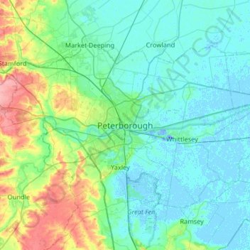
Nome: Mappa topografica Peterborough, altitudine, rilievo.
Altitudine media: 17 m
Altitudine minima: -19 m
Altitudine massima: 92 m
Altre mappe topografiche
Clicca su una mappa per visualizzarne la topografia, l'altitudine e il rilievo.
Cambridge
United Kingdom > England > Cambridgeshire
The city, like most of the UK, has a maritime climate highly influenced by the Gulf Stream. Located in the driest region of Britain, Cambridge's rainfall averages around 570 mm (22.44 in) per year, around half the national average, The driest recent year was in 2011 with 380.4 mm (14.98 in) of rain at the…
Altitudine media: 18 m
Ely
United Kingdom > England > Cambridgeshire
Ely is built on a 23-square-mile (60 km2) Kimmeridge Clay island which, at 85 feet (26 m), is the highest land in the Fens. It was due to this topography that Ely was not waterlogged like the surrounding Fenland, and was an island separated from the mainland. Major rivers including the Witham, Welland, Nene…
Altitudine media: 4 m
Great Staughton
United Kingdom > England > Cambridgeshire > Huntingdonshire > Great Staughton
Altitudine media: 43 m
River Great Ouse or Ely Ouse
United Kingdom > England > Cambridgeshire > East Cambridgeshire > Soham > Stuntney
Altitudine media: 4 m
Brampton
United Kingdom > England > Cambridgeshire > Huntingdonshire > Brampton
Altitudine media: 22 m
Westley Waterless
United Kingdom > England > Cambridgeshire > East Cambridgeshire
Altitudine media: 92 m
Hinchingbrooke Country Park
United Kingdom > England > Cambridgeshire > Huntingdonshire > Huntingdon > Brampton
Altitudine media: 16 m
Kimbolton
United Kingdom > England > Cambridgeshire > Huntingdonshire > Kimbolton
Altitudine media: 54 m
Great Abington
United Kingdom > England > Cambridgeshire > South Cambridgeshire
Altitudine media: 55 m
Great Shelford
United Kingdom > England > Cambridgeshire > South Cambridgeshire
Altitudine media: 22 m
Bluntisham
United Kingdom > England > Cambridgeshire > Huntingdonshire > Bluntisham
Altitudine media: 12 m
Stretham
United Kingdom > England > Cambridgeshire > East Cambridgeshire > Stretham
Altitudine media: 4 m
Kings Ripton
United Kingdom > England > Cambridgeshire > Huntingdonshire > Kings Ripton
Altitudine media: 34 m