
Mappa topografica Yarpole
Clicca sulla mappa per visualizzare l'altitudine.
A proposito di questa mappa
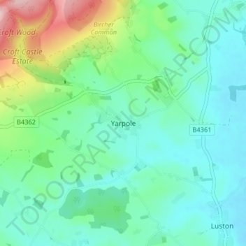
Nome: Mappa topografica Yarpole, altitudine, rilievo.
Luogo: Yarpole, Herefordshire, England, HR6 0BD, United Kingdom (52.25974 -2.79986 52.29974 -2.75986)
Altitudine media: 122 m
Altitudine minima: 72 m
Altitudine massima: 283 m
Altre mappe topografiche
Clicca su una mappa per visualizzarne la topografia, l'altitudine e il rilievo.
Croft Castle
United Kingdom > England > Herefordshire > Yarpole
The present building dates from the 1660s during the time when Herbert Croft was Bishop of Hereford, replacing an earlier house some thirty yards to the west, which was excavated by Herefordshire County Archaeologist Prof. Keith Ray and volunteers in 2002. The manor house is a quadrangular stone structure…
Altitudine media: 173 m
Eastnor Deer Park
United Kingdom > England > Herefordshire > Eastnor > Wayend Street
Altitudine media: 134 m