
Mappa topografica Munsley
Clicca sulla mappa per visualizzare l'altitudine.
A proposito di questa mappa
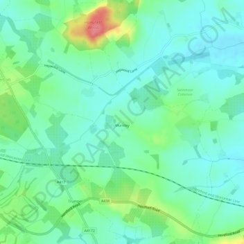
Nome: Mappa topografica Munsley, altitudine, rilievo.
Luogo: Munsley, Herefordshire, England, United Kingdom (52.04786 -2.51856 52.08320 -2.47073)
Altitudine media: 81 m
Altitudine minima: 60 m
Altitudine massima: 139 m
Altre mappe topografiche
Clicca su una mappa per visualizzarne la topografia, l'altitudine e il rilievo.
Bollitree Castle
United Kingdom > England > Herefordshire > Weston under Penyard
Altitudine media: 87 m
Bagpiper's Tump
United Kingdom > England > Herefordshire > Mordiford > Bagpiper's Tump
Altitudine media: 88 m
Eastnor Deer Park
United Kingdom > England > Herefordshire > Eastnor > Wayend Street
Altitudine media: 134 m
Hergest Ridge
United Kingdom > England > Herefordshire
Hergest Ridge is a large elongated hill which traverses the border between England and Wales in the United Kingdom, between the town of Kington in Herefordshire and the village of Gladestry in Powys. Its highest point, which is in England, is 426 metres (1,398 ft) high. It has a topographic prominence of 157.6…
Altitudine media: 308 m