Mappa topografica Lower Rea
Mappa interattiva
Clicca sulla mappa per visualizzare l'altitudine.
A proposito di questa mappa
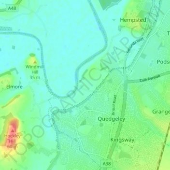
Altre mappe topografiche
Clicca su una mappa per visualizzarne la topografia, l'altitudine e il rilievo.
North Matson
United Kingdom > England > Gloucestershire > Gloucester
North Matson, Gloucester, Gloucestershire, England, United Kingdom
Altitudine media: 52 m
White City
United Kingdom > England > Gloucestershire > Gloucester
White City, Gloucester, Gloucestershire, England, GL4 6UL, United Kingdom
Altitudine media: 38 m
Kings Barton
United Kingdom > England > Gloucestershire > Gloucester
Kings Barton, Gloucester, Gloucestershire, England, GL1 1QT, United Kingdom
Altitudine media: 20 m
Saint Leonards Park
United Kingdom > England > Gloucestershire > Gloucester
Saint Leonards Park, Gloucester, Gloucestershire, England, GL4 6JX, United Kingdom
Altitudine media: 72 m
Quedgeley
United Kingdom > England > Gloucestershire > Gloucester
Quedgeley, Gloucester, Gloucestershire, England, United Kingdom
Altitudine media: 20 m
Abbeymead Contour Park
United Kingdom > England > Gloucestershire > Gloucester
Abbeymead Contour Park, Abbeydale, Gloucester, Gloucestershire, England, United Kingdom
Altitudine media: 46 m