
Mappa topografica Division No. 17
Clicca sulla mappa per visualizzare l'altitudine.
A proposito di questa mappa
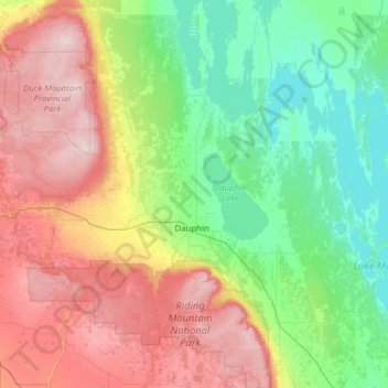
Nome: Mappa topografica Division No. 17, altitudine, rilievo.
Luogo: Division No. 17, Manitoba, Canada (50.50612 -100.97819 52.05875 -98.63398)
Altitudine media: 406 m
Altitudine minima: 244 m
Altitudine massima: 817 m
Altre mappe topografiche
Clicca su una mappa per visualizzarne la topografia, l'altitudine e il rilievo.
Turtle Mountain Provincial Park
Canada > Manitoba > Municipality of Boissevain – Morton
Turtle Mountain Provincial Park is situated on the Turtle Mountain (plateau), one of a number of significant geographic features located along the Manitoba Escarpment, the Canadian portion of the Pembina Escarpment. It is located in the Southwest Manitoba Uplands Ecoregion, within the Canadian Prairies. The…
Altitudine media: 662 m
Riding Mountain National Park
The climate in the Riding Mountain region is similar to that of other regions of southwestern Manitoba. Under the Köppen classification it has a continental climate. It includes grasslands, upland boreal and eastern deciduous forest ecosystems. The park has hot summers and cold winters, with annual rainfall…
Altitudine media: 488 m
Clear Lake
Canada > Manitoba > Division No. 18 > Rural Municipality of Grahamdale
Altitudine media: 251 m
Rowland Lake
Canada > Manitoba > Division No. 15 > Rural Municipality of Rosedale
Altitudine media: 692 m
Bakers Narrows
Canada > Manitoba > Division No. 21 > Unorganized Division No. 21
Altitudine media: 297 m
Elphinstone
Canada > Manitoba > Division No. 15 > Rural Municipality of Yellowhead
Altitudine media: 583 m
West Hawk Lake
Canada > Manitoba > Division No. 1 > Unorganized Division No. 1
Altitudine media: 349 m
Wasagaming
Canada > Manitoba > Unorganized Division No. 17
Wasagaming has a subarctic climate (Dfc) due to its northerly location and high elevation. Winters are extremely cold and relatively dry with little chance of a mid-winter thaw. The average annual temperature is 0.7 °C (33.3 °F). Annual precipitation is 488 mm (19.2 in).
Altitudine media: 630 m
Red River Floodway
Canada > Manitoba > Rural Municipality of Springfield > Winnipeg
Altitudine media: 236 m