
Fai una donazione
Equipaggiati per la tua prossima avventura:
In qualità di Affiliato Amazon, questo sito riceve una commissione sugli acquisti idonei, senza costi aggiuntivi per l’utente.
Mappa topografica Таскино
Clicca sulla mappa per visualizzare l'altitudine.
Fai una donazione
Equipaggiati per la tua prossima avventura:
In qualità di Affiliato Amazon, questo sito riceve una commissione sugli acquisti idonei, senza costi aggiuntivi per l’utente.
A proposito di questa mappa
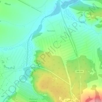
Nome: Mappa topografica Таскино, altitudine, rilievo.
Altitudine media: 251 m
Altitudine minima: 214 m
Altitudine massima: 328 m
Fai una donazione
Equipaggiati per la tua prossima avventura:
In qualità di Affiliato Amazon, questo sito riceve una commissione sugli acquisti idonei, senza costi aggiuntivi per l’utente.
Altre mappe topografiche
Clicca su una mappa per visualizzarne la topografia, l'altitudine e il rilievo.
Siberia
Russia > Krasnoyarsk Krai > Boguchansky Rayon
Eastern and central Sakha comprises numerous north–south mountain ranges of various ages. These mountains extend up to almost 3,000 metres (9,800 ft), but above a few hundred metres they are almost completely devoid of vegetation. The Verkhoyansk Range was extensively glaciated in the Pleistocene, but the…
Altitudine media: 346 m
Fai una donazione
Equipaggiati per la tua prossima avventura:
In qualità di Affiliato Amazon, questo sito riceve una commissione sugli acquisti idonei, senza costi aggiuntivi per l’utente.
Tunguska event
Russia > Krasnoyarsk Krai > Evenkiysky Rayon
The Tunguska event was a large explosion of between 3 and 50 megatons that occurred near the Podkamennaya Tunguska River in Yeniseysk Governorate (now Krasnoyarsk Krai), Russia, on the morning of 30 June 1908. The explosion over the sparsely populated East Siberian taiga felled a large number of trees, over an…
Altitudine media: 333 m
Fai una donazione
Equipaggiati per la tua prossima avventura:
In qualità di Affiliato Amazon, questo sito riceve una commissione sugli acquisti idonei, senza costi aggiuntivi per l’utente.
Byrranga Mountains
Russia > Krasnoyarsk Krai > Taymyrsky Dolgano-Nenetsky District
Altitudine media: 904 m
Fai una donazione
Equipaggiati per la tua prossima avventura:
In qualità di Affiliato Amazon, questo sito riceve una commissione sugli acquisti idonei, senza costi aggiuntivi per l’utente.
Zheleznogorsk
Russia > Krasnoyarsk Krai > Closed administrative-territorial formation of Zheleznogorsk
Zheleznogorsk is located 35 km north of Krasnoyarsk, in the foothills of the Atamanovsky Ridge, the spurs of the Sayan Mountains. The climate of the city, as in Krasnoyarsk, is Dfb according to Köppen. The average annual temperature is 2.2 °C or 36 °F. The city is located far from the southern border of…
Altitudine media: 220 m
Fai una donazione
Equipaggiati per la tua prossima avventura:
In qualità di Affiliato Amazon, questo sito riceve una commissione sugli acquisti idonei, senza costi aggiuntivi per l’utente.
Fai una donazione
Equipaggiati per la tua prossima avventura:
In qualità di Affiliato Amazon, questo sito riceve una commissione sugli acquisti idonei, senza costi aggiuntivi per l’utente.
Taymyr Peninsula
Russia > Krasnoyarsk Krai > Taymyrsky Dolgano-Nenetsky District
Altitudine media: 237 m
Fai una donazione
Equipaggiati per la tua prossima avventura:
In qualità di Affiliato Amazon, questo sito riceve una commissione sugli acquisti idonei, senza costi aggiuntivi per l’utente.
Fai una donazione
Equipaggiati per la tua prossima avventura:
In qualità di Affiliato Amazon, questo sito riceve una commissione sugli acquisti idonei, senza costi aggiuntivi per l’utente.
Fai una donazione
Equipaggiati per la tua prossima avventura:
In qualità di Affiliato Amazon, questo sito riceve una commissione sugli acquisti idonei, senza costi aggiuntivi per l’utente.
Fai una donazione
Equipaggiati per la tua prossima avventura:
In qualità di Affiliato Amazon, questo sito riceve una commissione sugli acquisti idonei, senza costi aggiuntivi per l’utente.
Krasnoyarsk
Russia > Krasnoyarsk Krai > Krasnoyarsk Urban Okrug
The river Yenisei flows from west to east through the city. Due to the Krasnoyarsk hydroelectric dam 32 km (20 mi) upstream, the Yenisei never freezes in winter and never exceeds +14 °C (57 °F) in summer through the city. Near the city center, its elevation is 136 m (446 ft) above sea level. There are…
Altitudine media: 285 m
Fai una donazione
Equipaggiati per la tua prossima avventura:
In qualità di Affiliato Amazon, questo sito riceve una commissione sugli acquisti idonei, senza costi aggiuntivi per l’utente.
Matusevich Ice Shelf
Russia > Krasnoyarsk Krai > Taymyrsky Dolgano-Nenetsky District
Altitudine media: 211 m
Krasnoyarsk
Russia > Krasnoyarsk Krai > Krasnoyarsk Urban Okrug
The river Yenisei flows from west to east through the city. Due to the Krasnoyarsk hydroelectric dam 32 km (20 mi) upstream, the Yenisei never freezes in winter and never exceeds +14 °C (57 °F) in summer through the city. Near the city center, its elevation is 136 m (446 ft) above sea level. There are…
Altitudine media: 285 m
Fai una donazione
Equipaggiati per la tua prossima avventura:
In qualità di Affiliato Amazon, questo sito riceve una commissione sugli acquisti idonei, senza costi aggiuntivi per l’utente.
Fai una donazione
Equipaggiati per la tua prossima avventura:
In qualità di Affiliato Amazon, questo sito riceve una commissione sugli acquisti idonei, senza costi aggiuntivi per l’utente.
Fai una donazione
Equipaggiati per la tua prossima avventura:
In qualità di Affiliato Amazon, questo sito riceve una commissione sugli acquisti idonei, senza costi aggiuntivi per l’utente.
сельское поселение Хатанга
Russia > Krasnoyarsk Krai > Taymyrsky Dolgano-Nenetsky District
Altitudine media: 157 m
Taymyr Peninsula
Russia > Krasnoyarsk Krai > Taymyrsky Dolgano-Nenetsky District
Altitudine media: 237 m
Fai una donazione
Equipaggiati per la tua prossima avventura:
In qualità di Affiliato Amazon, questo sito riceve una commissione sugli acquisti idonei, senza costi aggiuntivi per l’utente.
городское поселение Дудинка
Russia > Krasnoyarsk Krai > Taymyrsky Dolgano-Nenetsky District
Altitudine media: 271 m