
Fai una donazione
Equipaggiati per la tua prossima avventura:
In qualità di Affiliato Amazon, questo sito riceve una commissione sugli acquisti idonei, senza costi aggiuntivi per l’utente.
Mappa topografica Красноярск
Clicca sulla mappa per visualizzare l'altitudine.
Fai una donazione
Equipaggiati per la tua prossima avventura:
In qualità di Affiliato Amazon, questo sito riceve una commissione sugli acquisti idonei, senza costi aggiuntivi per l’utente.
Красноярск
La temperatura media a gennaio è di −20 °C, a luglio di 18 °C; la minima temperatura mai registrata è stata di −56 °C, la massima è stata di 36 °C. A causa del lago artificiale di una centrale idroelettrica situata a 32 km a monte della città, il fiume non gela mai d'inverno e la sua temperatura non supera i 14 °C d'estate. L'altitudine dello Enisej nel centro della città è 136 metri sul livello del mare.
Fai una donazione
Equipaggiati per la tua prossima avventura:
In qualità di Affiliato Amazon, questo sito riceve una commissione sugli acquisti idonei, senza costi aggiuntivi per l’utente.
A proposito di questa mappa
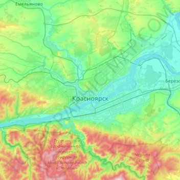
Nome: Mappa topografica Красноярск, altitudine, rilievo.
Altitudine media: 285 m
Altitudine minima: 118 m
Altitudine massima: 792 m
Fai una donazione
Equipaggiati per la tua prossima avventura:
In qualità di Affiliato Amazon, questo sito riceve una commissione sugli acquisti idonei, senza costi aggiuntivi per l’utente.