
Mappa topografica Broadstairs
Clicca sulla mappa per visualizzare l'altitudine.
A proposito di questa mappa
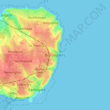
Nome: Mappa topografica Broadstairs, altitudine, rilievo.
Luogo: Broadstairs, Thanet, Kent, England, CT10 1BH, United Kingdom (51.31868 1.40079 51.39868 1.48079)
Altitudine media: 14 m
Altitudine minima: 0 m
Altitudine massima: 57 m
Altre mappe topografiche
Clicca su una mappa per visualizzarne la topografia, l'altitudine e il rilievo.
Ramsgate
United Kingdom > England > Kent > Thanet > Pegwell
In 2017 Ramsgate was chosen as one of the first ten Heritage Action Zones (HAZ) by Historic England, with the aim of stimulating economic growth by taking advantage of Ramsgate's historic environment. Part of this project included a Historic Landscape Characterisation Study which assessed and mapped the…
Altitudine media: 25 m
Ramsgate
United Kingdom > England > Kent > Thanet
In 2017 Ramsgate was chosen as one of the first ten Heritage Action Zones (HAZ) by Historic England, with the aim of stimulating economic growth using Ramsgate's historic environment as a catalyst. Part of this project included a Historic Landscape Characterisation Study which assessed and mapped the patterns…
Altitudine media: 25 m