
Mappa topografica Riddells Creek
Clicca sulla mappa per visualizzare l'altitudine.
A proposito di questa mappa
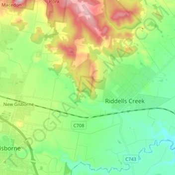
Nome: Mappa topografica Riddells Creek, altitudine, rilievo.
Altitudine media: 450 m
Altitudine minima: 285 m
Altitudine massima: 780 m
Altre mappe topografiche
Clicca su una mappa per visualizzarne la topografia, l'altitudine e il rilievo.
City of Melbourne
Melbourne's topography is characterized by a diverse landscape that transitions from flat coastal plains to rolling hills and mountainous regions. The city is situated at the northern end of Port Phillip Bay, where the terrain is predominantly flat, facilitating urban development. As one moves eastward, the…
Altitudine media: 18 m
Melbourne
Melbourne is also prone to isolated convective showers forming when a cold pool crosses the state, especially if there is considerable daytime heating. These showers are often heavy and can include hail, squalls, and significant drops in temperature, but they often pass through very quickly with a rapid…
Altitudine media: 185 m
Ballarat
Ballarat has a moderate oceanic climate (Köppen climate classification Cfb) with four distinct seasons. Its elevation, ranging between 400 and 630 metres (1,310 and 2,070 feet) above sea level, causes its mean monthly temperatures to tend to be on average 3 to 5 °C (5 to 9 °F) below those of Melbourne,…
Altitudine media: 470 m
Mount Buller
Due to its far south-western location in the alpine region, Mount Buller is more susceptible to cold airmasses which allow it to record some of the lowest maximum temperatures and daytime readings in the country, despite being considerably lower in elevation than other mountain sites to the north-east. On 5…
Altitudine media: 824 m
Mount Clear
Mount Clear is characterised by its topography of gently undulating hills flanked by bush and pine plantation forestry. Canadian Creek, on the suburb's eastern border, flows southward.
Altitudine media: 447 m
Bairnsdale
A comprehensive geological survey of Victoria's Great Dividing Range reveals a distinct north-south alignment in its bedrock, a vestige of the bygone epochs of plate tectonics. This enduring geological framework, coupled with ongoing tectonic activity, contributes to the dynamic topography witnessed in the…
Altitudine media: 25 m
Albert Park
Heritage Victoria notes that Albert Park's St Vincent Gardens "is historically important as the premier 'square' development in Victoria based on similar models in London. It is significant as the largest development of its type in Victoria and for its unusual development as gardens rather than the more usual…
Altitudine media: 6 m
Melbourne
Melbourne is also prone to isolated convective showers forming when a cold pool crosses the state, especially if there is considerable daytime heating. These showers are often heavy and can include hail, squalls, and significant drops in temperature, but they often pass through very quickly with a rapid…
Altitudine media: 49 m
Camberwell
Australia > Victoria > Melbourne
The Prospect Hill Road Precinct area is adjacent to the railway station and is the oldest part of the suburb. The original subdivision was relatively generous blocks, which were quickly filled with fine Victorian and Edwardian houses. Due to its hilly topography, many east–west streets in the Prospect Hill…
Altitudine media: 66 m
Grampians National Park
Mount William is known within the gliding community for the "Grampians Wave", a weather phenomenon that sometimes enables glider pilots to reach extreme altitudes of the order of 28,000 ft (8,500 m). This predominantly occurs during the months of May, June, September and October when strong westerly winds flow…
Altitudine media: 262 m
Falls Creek
The Falls Creek Alpine Resort is an alpine ski resort in the Hume region in northeastern Victoria, Australia. It is located in the Alpine National Park in the Victorian Alps, approximately 350 kilometres (220 miles) by road from Melbourne, with the nearest town Mount Beauty, approximately 30 km (20 mi) away.…
Altitudine media: 1’459 m
Forrest
Hemmed in by a rising ocean that stabilised about 7000 years ago, the uplifted sedimentary rocks of the Otway Range run from north-east to south-west at an elevation of about 500 metres above the sea. A few isolated peaks reach up to 675 metres, and at many points along this coastline bare mountains and…
Altitudine media: 212 m
Castlemaine
The Castlemaine goldfields' legendary prosperity raised expectations of Castlemaine becoming Victoria's second city. That is reflected in imposing buildings erected in the town's first few years. Though the rich alluvial diggings were largely exhausted within 15-20 years causing the town's population to shrink…
Altitudine media: 331 m
Fitzroy
Australia > Victoria > Melbourne
Fitzroy's topography is flat. It is laid out in grid plan and is characterised by a fairly tightly spaced rectangular grid of medium-sized streets, with many of its narrow streets and back lanes facilitating only one-way traffic. Its built form is a legacy of its early history when a mixture of land uses was…
Altitudine media: 35 m