
Mappa topografica Franklin
Mappa interattiva
Clicca sulla mappa per visualizzare l'altitudine.
A proposito di questa mappa
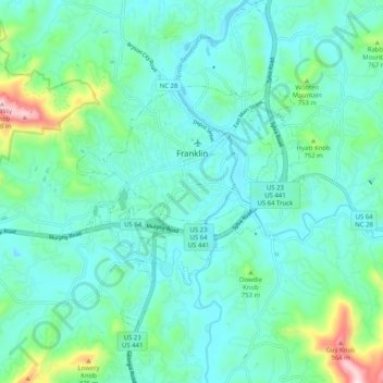
Nome: Mappa topografica Franklin, altitudine, rilievo.
Luogo: Franklin, Macon County, North Carolina, 28734, United States (35.13238 -83.43950 35.21556 -83.35178)
Altitudine media: 675 m
Altitudine minima: 598 m
Altitudine massima: 1’013 m
The height of the falls is given as 200 ft (61 m) in Kevin Adams' book, North Carolina Waterfalls and 250 ft (77.1 m) by NCWaterfalls.com. However, Google Earth gives a height (based on the elevation of the water at the top of the falls and the elevation of the plunge pool at the bottom of the falls) of 137 ft (42 m). The falls may be glimpsed by people driving along Highway 64, but it is difficult to see more fully from the road. The falls are located beside of a series of blind curves on with sheer rock cliffs above and below the road. A small pull-off is located near the falls, but walking on the road puts visitors in danger of being hit by a passing vehicle.
Altre mappe topografiche
Clicca su una mappa per visualizzarne la topografia, l'altitudine e il rilievo.
Highlands
United States > North Carolina > Macon County > Highlands
Highlands, Macon County, North Carolina, 28741, United States
Altitudine media: 1’090 m
Scaly Mountain
United States > North Carolina > Macon County
Scaly Mountain, Macon County, North Carolina, 28775, United States
Altitudine media: 1’071 m
Franklin
United States > North Carolina > Macon County > Franklin
Franklin, Macon County, North Carolina, 28734, United States
Altitudine media: 665 m
Otto
United States > North Carolina > Macon County
Otto, Macon County, North Carolina, 28763, United States
Altitudine media: 676 m
Highlands
United States > North Carolina > Macon County
Highlands, Macon County, North Carolina, 28741, United States
Altitudine media: 1’116 m