
Mappa topografica Highlands
Mappa interattiva
Clicca sulla mappa per visualizzare l'altitudine.
A proposito di questa mappa
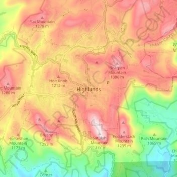
Nome: Mappa topografica Highlands, altitudine, rilievo.
Altitudine media: 1’116 m
Altitudine minima: 820 m
Altitudine massima: 1’360 m
Highlands was founded in 1875 after its two founders, Samuel Truman Kelsey and Clinton Carter Hutchinson, drew lines from Chicago to Savannah and from New Orleans to New York City. They felt that the place where these lines met would eventually become a great trading center and commercial crossroads. Highlands was named for its lofty elevation.
Altre mappe topografiche
Clicca su una mappa per visualizzarne la topografia, l'altitudine e il rilievo.
Highlands
United States > North Carolina > Macon County > Highlands
Highlands, Macon County, North Carolina, 28741, United States
Altitudine media: 1’090 m
Franklin
United States > North Carolina > Macon County
Franklin, Macon County, North Carolina, 28734, United States
Altitudine media: 675 m
Scaly Mountain
United States > North Carolina > Macon County
Scaly Mountain, Macon County, North Carolina, 28775, United States
Altitudine media: 1’071 m
Franklin
United States > North Carolina > Macon County > Franklin
Franklin, Macon County, North Carolina, 28734, United States
Altitudine media: 665 m
Otto
United States > North Carolina > Macon County
Otto, Macon County, North Carolina, 28763, United States
Altitudine media: 676 m