
Mappa topografica Errol
Mappa interattiva
Clicca sulla mappa per visualizzare l'altitudine.
A proposito di questa mappa
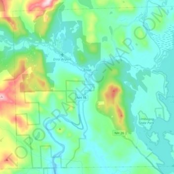
Nome: Mappa topografica Errol, altitudine, rilievo.
Luogo: Errol, Coös County, New Hampshire, United States (44.70826 -71.21592 44.82853 -71.03441)
Altitudine media: 453 m
Altitudine minima: 358 m
Altitudine massima: 821 m
According to the United States Census Bureau, the town has a total area of 69.5 square miles (179.9 km2), of which 60.3 square miles (156.3 km2) are land and 9.1 square miles (23.5 km2) are water, comprising 13.09% of the town. The Androscoggin River begins in Errol, where the Magalloway River joins the outlet of Umbagog Lake. The town's elevation reaches 2,350 feet (720 m) above sea level atop a bump above Signal Pond near the town's western boundary. Errol lies fully within the Androscoggin River watershed.
Altre mappe topografiche
Clicca su una mappa per visualizzarne la topografia, l'altitudine e il rilievo.
Holden Hill
United States > New Hampshire > Coos County > Stewartstown
Holden Hill, Stewartstown, Coös County, New Hampshire, United States
Altitudine media: 660 m
Upper Village
United States > New Hampshire > Coos County > Gorham
Upper Village, Gorham, Coös County, New Hampshire, 03581, United States
Altitudine media: 343 m
Success
United States > New Hampshire > Coos County
Success, Coos County, New Hampshire, United States
Altitudine media: 565 m
Lombard Pond
United States > New Hampshire > Coos County > Colebrook
Lombard Pond, Colebrook, Coos County, New Hampshire, United States
Altitudine media: 402 m
Mount Martha
United States > New Hampshire > Coos County > Carroll
Mount Martha, Carroll, Coös County, New Hampshire, United States
Altitudine media: 823 m