
Mappa topografica Success
Mappa interattiva
Clicca sulla mappa per visualizzare l'altitudine.
A proposito di questa mappa
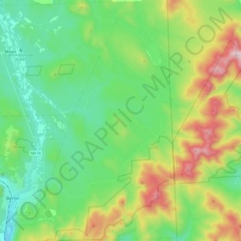
Nome: Mappa topografica Success, altitudine, rilievo.
Luogo: Success, Coos County, New Hampshire, United States (44.43819 -71.16202 44.61030 -71.01878)
Altitudine media: 565 m
Altitudine minima: 259 m
Altitudine massima: 1’259 m
The highest point in the township is the summit of Mount Success, with an elevation of 3,565 feet (1,087 m) above sea level, in the southeast part of the township along the crest of the Mahoosucs. The Appalachian Trail follows the Mahoosuc crest across the township.
Altre mappe topografiche
Clicca su una mappa per visualizzarne la topografia, l'altitudine e il rilievo.
Errol
United States > New Hampshire > Coos County
Errol, Coös County, New Hampshire, United States
Altitudine media: 453 m
Holden Hill
United States > New Hampshire > Coos County > Stewartstown
Holden Hill, Stewartstown, Coös County, New Hampshire, United States
Altitudine media: 660 m
Upper Village
United States > New Hampshire > Coos County > Gorham
Upper Village, Gorham, Coös County, New Hampshire, 03581, United States
Altitudine media: 343 m
Lombard Pond
United States > New Hampshire > Coos County > Colebrook
Lombard Pond, Colebrook, Coos County, New Hampshire, United States
Altitudine media: 402 m