
Mappa topografica Liard River
Clicca sulla mappa per visualizzare l'altitudine.
A proposito di questa mappa
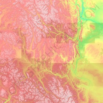
Nome: Mappa topografica Liard River, altitudine, rilievo.
Luogo: Liard River, Canada (59.26363 -131.71904 61.86064 -121.20048)
Altitudine media: 992 m
Altitudine minima: 98 m
Altitudine massima: 2’752 m
Altre mappe topografiche
Clicca su una mappa per visualizzarne la topografia, l'altitudine e il rilievo.
Toronto
Despite its deep ravines, Toronto is not remarkably hilly, but its elevation does increase steadily away from the lake. Elevation differences range from 76.5 metres (251 ft) above sea level at the Lake Ontario shore to 209 m (686 ft) ASL near the York University grounds in the city's north end at the…
Altitudine media: 113 m
London
Canada > Ontario > London > London
London has a humid continental climate (Köppen Dfb), though due to its downwind location relative to Lake Huron and elevation changes across the city, it is virtually on the Dfa/Dfb (hot summer) boundary favouring the former climate zone to the southwest of the confluence of the South and North Thames Rivers,…
Altitudine media: 268 m
Peterborough
Canada > Ontario > Peterborough
Peterborough's topography is largely defined by land formations created by the receding Wisconsian glaciers 10,000–15,000 years ago. The South End and Downtown portions of the City sit on what was the bottom of the glacial Lake Peterborough—part of a glacial spillway created when glacial meltwaters from…
Altitudine media: 235 m
Guelph
This region of Ontario has cold winters and warm, humid summers, falling into the Köppen climate classification Dfb zone, with moderately high rainfall and snowfall. It is generally a couple of degrees cooler than lower elevation regions on the Great Lakes shorelines, especially so in winter, the exception…
Altitudine media: 344 m
Silent Lake Provincial Park
Canada > Ontario > Haliburton County > Highlands East
Altitudine media: 371 m
Banff
Canada > Alberta > Banff > Banff
Banff is a town within Banff National Park in Alberta, Canada. It is located in Alberta's Rockies along the Trans-Canada Highway, approximately 126 km (78 mi) west of Calgary and 58 km (36 mi) east of Lake Louise. At 1,400 to 1,630 m (4,590 to 5,350 ft) above sea level, Banff is the community with the second…
Altitudine media: 1’615 m
Lethbridge
Canada > Alberta > Lethbridge
Its high elevation of 929 m (3,047.9 ft) and close proximity to the Rocky Mountains provides Lethbridge with cooler summers than other locations in the Canadian Prairies. These factors protect the city from strong northwest and southwest winds and contribute to frequent chinook winds during the winter.…
Altitudine media: 918 m
Lake Louise
Canada > Alberta > Improvement District No. 9
Lake Louise is a hamlet within Banff National Park in Alberta, Canada. Named after Princess Louise, Duchess of Argyll, it lies in Alberta's Rockies on the Bow River, 3 km (1.9 mi) northeast of the lake that shares its name. Initially settled in 1884 as an outpost for the Canadian Pacific Railway, Lake Louise…
Altitudine media: 1’617 m
Riding Mountain National Park
The climate in the Riding Mountain region is similar to that of other regions of southwestern Manitoba. Under the Köppen classification it has a continental climate. It includes grasslands, upland boreal and eastern deciduous forest ecosystems. The park has hot summers and cold winters, with annual rainfall…
Altitudine media: 488 m
Cowichan Bay
Canada > British Columbia > Cowichan Valley Regional District > Area D (Cowichan Bay)
Altitudine media: 40 m
Vernon Hill
Canada > British Columbia > Regional District of North Okanagan > Area C (Silver Star)
Altitudine media: 1’237 m
Mont Gosford
Canada > Quebec > Le Granit > Saint-Augustin-de-Woburn
Since 1978, Mount Gosford is included in "ZEC Louise-Gosford", a controlled harvesting zone open to the public. Recently, the areas at more than 700 metres of altitude were designated Important Bird Areas due to the presence Bicknell's thrushes, an endemic species living in mountain peaks of northeast North…
Altitudine media: 933 m
Thompson River
Canada > British Columbia > Thompson-Nicola Regional District
Altitudine media: 1’127 m
Caliper Lake Provincial Park
Canada > Ontario > Kenora District > Sioux Narrows-Nestor Falls Township
Altitudine media: 338 m
Nose Hill Park
Names currently associated with topographical features in and near Nose Hill Park reflect the impact of the European newcomers and European trade goods on the Peigan. For example, Spy Hill, the westward extension of Nose Hill, derived its present name from the aboriginal practice of communicating with distant…
Altitudine media: 1’174 m
Kootenay National Park
Canada > British Columbia > Regional District of East Kootenay
Kootenay National Park is a national park located in southeastern British Columbia, Canada, and is one component of the Canadian Rocky Mountain Parks World Heritage Site. The park consists of 1,406 km2 (543 sq mi) of the Canadian Rockies, including parts of the Kootenay and Park mountain ranges, the Kootenay…
Altitudine media: 1’832 m
Blue Mountain Park
Canada > British Columbia > Metro Vancouver Regional District > Coquitlam
Altitudine media: 119 m
Lone Butte
Canada > British Columbia > Cariboo Regional District > Area L (Lone Butte/Interlakes)
The northward advance of the Pacific Great Eastern Railway (PGE) rail head passed through Lone Butte in late April 1919. This construction camp had a large kitchen employing 25 cooks, of whom two received the Distinguished Conduct Medal and three the Military Medal during World War I. At an elevation of about…
Altitudine media: 1’159 m
Fox Creek
Canada > Alberta > Town of Fox Creek
Fox Creek is a town in northwest Alberta, Canada. It is located on Highway 43, approximately 259 km (161 mi) northwest of Edmonton and 199 km (124 mi) southeast of Grande Prairie, and has an elevation of 808 m (2,651 ft).
Altitudine media: 834 m
Laurentian Mountains
One of Quebec's official regions is called Laurentides. The mountain range runs through four other regions; Capitale-Nationale, Outaouais, Lanaudière, and Mauricie. The elevation generally ranges from around 500 m (1,640 ft) to 1,000 m (3,280 ft) with Mont Raoul-Blanchard being its highest peak, at 1,166 m…
Altitudine media: 348 m
Kamloops
Canada > British Columbia > Thompson-Nicola Regional District > Kamloops
Altitudine media: 875 m
Cachalot
Canada > British Columbia > Strathcona Regional District > Area A (Kyuquot/Nootka/Sayward)
Altitudine media: 386 m
Mount Garibaldi
Canada > British Columbia > Fraser Valley Regional District > Area F (McConnell Creek/Hatzic Prairie)
Mount Garibaldi (Squamish: Nch'ḵay̓, pronounced [n̩.ʧʼqɛˀj̰]) is a dormant stratovolcano in the Garibaldi Ranges of the Pacific Ranges in southwestern British Columbia, Canada. It has a maximum elevation of 2,678 metres (8,786 feet) and rises above the surrounding landscape on the east side of the…
Altitudine media: 2’146 m
Crawford Bay
Canada > British Columbia > Regional District of Central Kootenay > Area A (Wynndel/Crawford Bay/Riondel)
Altitudine media: 667 m
Stanley Park
Canada > British Columbia > Metro Vancouver Regional District > Vancouver
Altitudine media: 14 m
Grouse Mountain
Canada > British Columbia > Metro Vancouver Regional District
Grouse Mountain is one of the North Shore Mountains of the Pacific Ranges in the District Municipality of North Vancouver, British Columbia, Canada. With a maximum elevation of over 1,200 m (4,100 feet) at its peak, the mountain is the site of an alpine ski area, Grouse Mountain Resort, which overlooks Greater…
Altitudine media: 968 m
Whistler
Canada > British Columbia > Squamish-Lillooet Regional District > Whistler Resort Municipality > Whistler
Altitudine media: 996 m
Grande Prairie
Canada > Alberta > Grande Prairie
Grande Prairie is located just north of the 55th parallel north, and is 465 km (289 mi) northwest of Edmonton, lying at an elevation of 669 m (2,195 ft) above sea level. The city is surrounded by farmland to the north, east, and west. To the south lies a vast boreal forest with aspen, tamarack, lodgepole pine,…
Altitudine media: 668 m