
Mappa topografica Wotton
Clicca sulla mappa per visualizzare l'altitudine.
A proposito di questa mappa
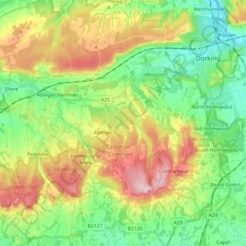
Nome: Mappa topografica Wotton, altitudine, rilievo.
Luogo: Wotton, Mole Valley, Surrey, England, United Kingdom (51.15232 -0.41096 51.25701 -0.33569)
Altitudine media: 135 m
Altitudine minima: 39 m
Altitudine massima: 290 m
Altre mappe topografiche
Clicca su una mappa per visualizzarne la topografia, l'altitudine e il rilievo.
Box Hill
United Kingdom > England > Surrey > Mole Valley > Pixham
The 15.8 km (9.8 mi) Box Hill Olympic circuit is generally cycled in an anticlockwise direction and begins to the south of the village of Mickleham with an ascent of the hill via the Zig Zag Road. From the National Trust Visitor Centre, the route turns eastwards, running along the escarpment and through the…
Altitudine media: 105 m
South Holmwood
United Kingdom > England > Surrey > Mole Valley > South Holmwood
Altitudine media: 116 m
Abinger Roughs
United Kingdom > England > Surrey > Mole Valley > Abinger Hammer
Altitudine media: 141 m
Box Hill
United Kingdom > England > Surrey > Mole Valley > Pixham
The 15.8 km (9.8 mi) Box Hill Olympic circuit is generally cycled in an anticlockwise direction and begins to the south of the village of Mickleham with an ascent of the hill via the Zig Zag Road. From the National Trust Visitor Centre, the route turns eastwards, running along the escarpment and through the…
Altitudine media: 105 m