
Mappa topografica Elappara
Clicca sulla mappa per visualizzare l'altitudine.
Elappara
Elappara is a town in Idukki district in the southwestern Indian state of Kerala. It is one of the panchayaths in Peerumedu taluk. The area is marked by a cool climate as the region is situated at an elevation of over 1,000 m (3,300 ft) above sea level. Elappara is famous for its vast tea plantations.
A proposito di questa mappa
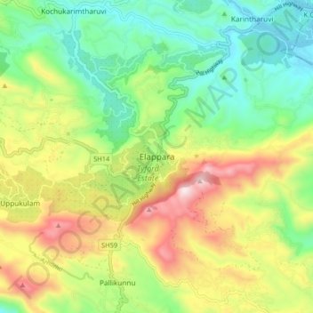
Nome: Mappa topografica Elappara, altitudine, rilievo.
Luogo: Elappara, Peerumade, Idukki, Kerala, 685501, India (9.59062 76.93847 9.67062 77.01847)
Altitudine media: 1’049 m
Altitudine minima: 762 m
Altitudine massima: 1’508 m
Altre mappe topografiche
Clicca su una mappa per visualizzarne la topografia, l'altitudine e il rilievo.
Periyar National Park Tiger Reserve
Periyar National Park lies in the middle of a mountainous area of the Cardamom Hills. In the north : The boundary commences from the point nearest to the Medaganam in the interstate boundary up to Vellimalai. and the east Thence the boundary follows the inter-state boundary from Vellimalai to Kallimalai Peak…
Altitudine media: 929 m