
Mappa topografica Black Butte
Mappa interattiva
Clicca sulla mappa per visualizzare l'altitudine.
A proposito di questa mappa
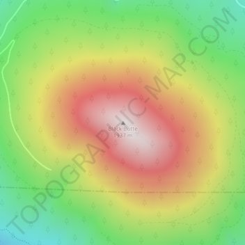
Nome: Mappa topografica Black Butte, altitudine, rilievo.
Luogo: Black Butte, Jefferson County, Oregon, United States (44.40003 -121.63651 44.40013 -121.63641)
Altitudine media: 1’514 m
Altitudine minima: 1’102 m
Altitudine massima: 1’952 m
According to the U.S. National Geodetic Survey and scientists from the United States Geological Survey, Black Butte has an elevation of 6,436 feet (1,962 m); the Geographic Names Information System database lists its elevation as 6,430 feet (1,960 m), while Oregon Geographic Names lists its elevation at 6,415 feet (1,955 m). The butte has proximal and draping reliefs of 2,490 feet (760 m) and 3,150 feet (960 m), which are the "difference between summit elevation and that of highest exposure of older rocks overlain by the edifice" and the "difference between summit elevation and that of lowest distal lavas of the edifice (not including distal pyroclastic or debris flows)," respectively. According to E. M. Taylor, Black Butte has a diameter of 4 miles (6.4 km).
Altre mappe topografiche
Clicca su una mappa per visualizzarne la topografia, l'altitudine e il rilievo.
Culver
United States > Oregon > Jefferson County
Culver, Jefferson County, Oregon, United States
Altitudine media: 807 m
Lake Billy Chinook
United States > Oregon > Jefferson County
Lake Billy Chinook, Jefferson County, Oregon, United States
Altitudine media: 776 m
Madras
United States > Oregon > Jefferson County
Madras, Jefferson County, Oregon, United States
Altitudine media: 739 m
Camp Sherman
United States > Oregon > Jefferson County
Camp Sherman, Jefferson County, Oregon, 97730, United States
Altitudine media: 939 m
Crooked River Ranch
United States > Oregon > Jefferson County
Crooked River Ranch, Jefferson County, Oregon, United States
Altitudine media: 825 m
Peter Skene Ogden State Scenic Viewport
United States > Oregon > Jefferson County
Peter Skene Ogden State Scenic Viewport, Jefferson County, Oregon, United States
Altitudine media: 839 m
Warm Springs
United States > Oregon > Jefferson County > Warm Springs
Warm Springs, Jefferson County, Oregon, 97761, United States
Altitudine media: 650 m
Mount Jefferson
United States > Oregon > Jefferson County
Mount Jefferson, Jefferson County, Oregon, United States
Altitudine media: 2’537 m