
Fai una donazione
Equipaggiati per la tua prossima avventura:
In qualità di Affiliato Amazon, questo sito riceve una commissione sugli acquisti idonei, senza costi aggiuntivi per l’utente.
Mappa topografica Culver
Clicca sulla mappa per visualizzare l'altitudine.
Fai una donazione
Equipaggiati per la tua prossima avventura:
In qualità di Affiliato Amazon, questo sito riceve una commissione sugli acquisti idonei, senza costi aggiuntivi per l’utente.
A proposito di questa mappa
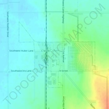
Nome: Mappa topografica Culver, altitudine, rilievo.
Luogo: Culver, Jefferson County, Oregon, United States (44.51631 -121.22550 44.53268 -121.19909)
Altitudine media: 807 m
Altitudine minima: 795 m
Altitudine massima: 838 m
Fai una donazione
Equipaggiati per la tua prossima avventura:
In qualità di Affiliato Amazon, questo sito riceve una commissione sugli acquisti idonei, senza costi aggiuntivi per l’utente.
Altre mappe topografiche
Clicca su una mappa per visualizzarne la topografia, l'altitudine e il rilievo.
Mount Jefferson
United States > Oregon > Jefferson County
The second tallest mountain in the U.S. state of Oregon after Mount Hood, Mount Jefferson lies within Jefferson, Linn, and Marion counties, in the central part of the state. Reaching an elevation of 10,497 feet (3,199 m), the volcano has a proximal relief of 4,890 feet (1,490 m). It is not usually visible from…
Altitudine media: 2’537 m
Black Butte
United States > Oregon > Jefferson County
According to the U.S. National Geodetic Survey and scientists from the United States Geological Survey, Black Butte has an elevation of 6,436 feet (1,962 m); the Geographic Names Information System database lists its elevation as 6,430 feet (1,960 m), while Oregon Geographic Names lists its elevation at 6,415…
Altitudine media: 1’514 m
Mount Jefferson
United States > Oregon > Jefferson County
The second tallest mountain in the U.S. state of Oregon after Mount Hood, Mount Jefferson lies within Jefferson, Linn, and Marion counties, in the central part of the state. Reaching an elevation of 10,497 feet (3,199 m), the volcano has a proximal relief of 4,890 feet (1,490 m). It is not usually visible from…
Altitudine media: 2’537 m
Fai una donazione
Equipaggiati per la tua prossima avventura:
In qualità di Affiliato Amazon, questo sito riceve una commissione sugli acquisti idonei, senza costi aggiuntivi per l’utente.