
Fai una donazione
Equipaggiati per la tua prossima avventura:
In qualità di Affiliato Amazon, questo sito riceve una commissione sugli acquisti idonei, senza costi aggiuntivi per l’utente.
Mappa topografica Bakewell CP
Clicca sulla mappa per visualizzare l'altitudine.
Fai una donazione
Equipaggiati per la tua prossima avventura:
In qualità di Affiliato Amazon, questo sito riceve una commissione sugli acquisti idonei, senza costi aggiuntivi per l’utente.
Bakewell CP
The Manchester, Buxton, Matlock and Midlands Junction Railway opened Bakewell railway station in 1862, then became part of the Midland Railway and later of the LMS main line from London to Manchester. John Ruskin objected to what he saw as desecration of the Derbyshire countryside and to the fact that "every fool in Buxton can be at Bakewell in half an hour, and every fool in Bakewell at Buxton." In return for the Duke of Rutland's permission for the line to pass through his estate at Haddon Hall, Bakewell station buildings on the hillside overlooking the town are more imposing than expected and the Duke's coat of arms is carved in the stonework. Such pandering to landowners was common at the time, as their support was needed to pass the Act of Parliament allowing the line to be built. However, the inconvenient altitude of the line forced Bakewell station to be placed out of town, as the Duke insisted it be out of sight of Haddon Hall. These buildings are now used by small businesses, as the line between Matlock and Buxton was closed in 1968. Most of it has been designated the Monsal Trail, a bridle path for walking, cycling and riding.
Fai una donazione
Equipaggiati per la tua prossima avventura:
In qualità di Affiliato Amazon, questo sito riceve una commissione sugli acquisti idonei, senza costi aggiuntivi per l’utente.
A proposito di questa mappa
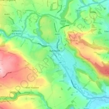
Nome: Mappa topografica Bakewell CP, altitudine, rilievo.
Altitudine media: 194 m
Altitudine minima: 103 m
Altitudine massima: 353 m
Fai una donazione
Equipaggiati per la tua prossima avventura:
In qualità di Affiliato Amazon, questo sito riceve una commissione sugli acquisti idonei, senza costi aggiuntivi per l’utente.
Altre mappe topografiche
Clicca su una mappa per visualizzarne la topografia, l'altitudine e il rilievo.
Stanage Plantation
United Kingdom > England > Derbyshire > Derbyshire Dales > Hathersage
Altitudine media: 360 m
Fai una donazione
Equipaggiati per la tua prossima avventura:
In qualità di Affiliato Amazon, questo sito riceve una commissione sugli acquisti idonei, senza costi aggiuntivi per l’utente.
Hallam Moors
United Kingdom > England > Derbyshire > Derbyshire Dales > Hathersage
Altitudine media: 368 m
Slaley
United Kingdom > England > Derbyshire > Derbyshire Dales > Matlock > Bonsall CP
Altitudine media: 263 m
Fai una donazione
Equipaggiati per la tua prossima avventura:
In qualità di Affiliato Amazon, questo sito riceve una commissione sugli acquisti idonei, senza costi aggiuntivi per l’utente.
Bolehill
United Kingdom > England > Derbyshire > Derbyshire Dales > Wirksworth CP
Altitudine media: 220 m
Fai una donazione
Equipaggiati per la tua prossima avventura:
In qualità di Affiliato Amazon, questo sito riceve una commissione sugli acquisti idonei, senza costi aggiuntivi per l’utente.
Two Dales
United Kingdom > England > Derbyshire > Derbyshire Dales > Darley Dale CP > Darley Hillside
Altitudine media: 189 m
Starkholmes
United Kingdom > England > Derbyshire > Derbyshire Dales > Matlock
Altitudine media: 175 m
Fai una donazione
Equipaggiati per la tua prossima avventura:
In qualità di Affiliato Amazon, questo sito riceve una commissione sugli acquisti idonei, senza costi aggiuntivi per l’utente.
Farley Wood
United Kingdom > England > Derbyshire > Derbyshire Dales > Matlock
Altitudine media: 255 m
Magpie Mine
United Kingdom > England > Derbyshire > Derbyshire Dales > Ashford in the Water CP
Altitudine media: 303 m
Fai una donazione
Equipaggiati per la tua prossima avventura:
In qualità di Affiliato Amazon, questo sito riceve una commissione sugli acquisti idonei, senza costi aggiuntivi per l’utente.
Catcliff Wood
United Kingdom > England > Derbyshire > Derbyshire Dales > Bakewell CP
Altitudine media: 173 m
Gang Mine
United Kingdom > England > Derbyshire > Derbyshire Dales > Cromford CP
Altitudine media: 226 m
Taddington Dale
United Kingdom > England > Derbyshire > Derbyshire Dales > Brushfield CP
Altitudine media: 281 m
Cressbrook Dale
United Kingdom > England > Derbyshire > Derbyshire Dales > Litton CP > Litton Mill
Altitudine media: 286 m
Fai una donazione
Equipaggiati per la tua prossima avventura:
In qualità di Affiliato Amazon, questo sito riceve una commissione sugli acquisti idonei, senza costi aggiuntivi per l’utente.
Curbar Edge
United Kingdom > England > Derbyshire > Derbyshire Dales > Curbar CP
Altitudine media: 252 m
Hathersage Booths
United Kingdom > England > Derbyshire > Derbyshire Dales > Hathersage
Altitudine media: 260 m
Fai una donazione
Equipaggiati per la tua prossima avventura:
In qualità di Affiliato Amazon, questo sito riceve una commissione sugli acquisti idonei, senza costi aggiuntivi per l’utente.
Fai una donazione
Equipaggiati per la tua prossima avventura:
In qualità di Affiliato Amazon, questo sito riceve una commissione sugli acquisti idonei, senza costi aggiuntivi per l’utente.
Black Rocks
United Kingdom > England > Derbyshire > Derbyshire Dales > Cromford CP
Altitudine media: 199 m
Curbar Edge
United Kingdom > England > Derbyshire > Derbyshire Dales > Calver Sough
Altitudine media: 251 m
Fai una donazione
Equipaggiati per la tua prossima avventura:
In qualità di Affiliato Amazon, questo sito riceve una commissione sugli acquisti idonei, senza costi aggiuntivi per l’utente.
Riber Castle
United Kingdom > England > Derbyshire > Derbyshire Dales > Matlock > Starkholmes
Altitudine media: 169 m
Monsal Head
United Kingdom > England > Derbyshire > Derbyshire Dales > Cressbrook > Monsal Head
Altitudine media: 231 m
Fai una donazione
Equipaggiati per la tua prossima avventura:
In qualità di Affiliato Amazon, questo sito riceve una commissione sugli acquisti idonei, senza costi aggiuntivi per l’utente.
Breamfield
United Kingdom > England > Derbyshire > Derbyshire Dales > Wirksworth CP > Breamfield
Altitudine media: 213 m
Coplow Dale
United Kingdom > England > Derbyshire > Derbyshire Dales > Little Hucklow
Altitudine media: 333 m
Stoke Brook
United Kingdom > England > Derbyshire > Derbyshire Dales > Calver Sough
Altitudine media: 197 m
Fai una donazione
Equipaggiati per la tua prossima avventura:
In qualità di Affiliato Amazon, questo sito riceve una commissione sugli acquisti idonei, senza costi aggiuntivi per l’utente.
Yarncliff Wood
United Kingdom > England > Derbyshire > Derbyshire Dales > Grindleford
Altitudine media: 260 m
Calver Sough
United Kingdom > England > Derbyshire > Derbyshire Dales > Calver Sough
Altitudine media: 218 m
Parsley Hay
United Kingdom > England > Derbyshire > Derbyshire Dales > Parsley Hay
Altitudine media: 334 m
Fai una donazione
Equipaggiati per la tua prossima avventura:
In qualità di Affiliato Amazon, questo sito riceve una commissione sugli acquisti idonei, senza costi aggiuntivi per l’utente.
Longstone Edge
United Kingdom > England > Derbyshire > Derbyshire Dales > Rowland
Altitudine media: 290 m
Arbor Low
United Kingdom > England > Derbyshire > Derbyshire Dales > Parsley Hay
Altitudine media: 342 m
Longcliffe
United Kingdom > England > Derbyshire > Derbyshire Dales > Brassington CP
Altitudine media: 299 m
Fai una donazione
Equipaggiati per la tua prossima avventura:
In qualità di Affiliato Amazon, questo sito riceve una commissione sugli acquisti idonei, senza costi aggiuntivi per l’utente.
Lathkill Dale
United Kingdom > England > Derbyshire > Derbyshire Dales > Youlgreave
Altitudine media: 269 m
Breamfield
United Kingdom > England > Derbyshire > Derbyshire Dales > Wirksworth CP
Altitudine media: 213 m
Fai una donazione
Equipaggiati per la tua prossima avventura:
In qualità di Affiliato Amazon, questo sito riceve una commissione sugli acquisti idonei, senza costi aggiuntivi per l’utente.
Wirksworth Moor
United Kingdom > England > Derbyshire > Derbyshire Dales > Wirksworth CP
Altitudine media: 207 m
Fai una donazione
Equipaggiati per la tua prossima avventura:
In qualità di Affiliato Amazon, questo sito riceve una commissione sugli acquisti idonei, senza costi aggiuntivi per l’utente.
Padley Gorge
United Kingdom > England > Derbyshire > Derbyshire Dales > Grindleford
Altitudine media: 316 m