
Mappa topografica Pikehall
Clicca sulla mappa per visualizzare l'altitudine.
A proposito di questa mappa
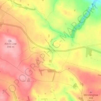
Nome: Mappa topografica Pikehall, altitudine, rilievo.
Altitudine media: 321 m
Altitudine minima: 207 m
Altitudine massima: 397 m
Altre mappe topografiche
Clicca su una mappa per visualizzarne la topografia, l'altitudine e il rilievo.
Ashbourne CP
United Kingdom > England > Derbyshire > Derbyshire Dales
Ashbourne lies at 53°01′N 01°44′W / 53.017°N 1.733°W / 53.017; -1.733. Ashbourne Green and Sturston are hamlets close by. Henmore Brook, a tributary of the River Dove, flows through the middle of the town. It has an elevation of 400 feet (122 m).
Altitudine media: 147 m
Riber Castle
United Kingdom > England > Derbyshire > Derbyshire Dales > Matlock > Starkholmes
Altitudine media: 169 m
Bakewell CP
United Kingdom > England > Derbyshire > Derbyshire Dales
The Manchester, Buxton, Matlock and Midlands Junction Railway opened Bakewell railway station in 1862, then became part of the Midland Railway and later of the LMS main line from London to Manchester. John Ruskin objected to what he saw as desecration of the Derbyshire countryside and to the fact that "a…
Altitudine media: 194 m
Hathersage
United Kingdom > England > Derbyshire > Derbyshire Dales
The Fat Boys Stanage Struggle is a popular local fell race that starts in Hathersage—altitude 91 metres (299 ft)—and routes up to and along Stanage Edge to High Neb—458 metres (1,503 ft)—before returning to the village 367 metres (1,204 ft) below.
Altitudine media: 311 m
Elton
United Kingdom > England > Derbyshire > Derbyshire Dales
At 271 metres (889 ft) above sea level, Elton is less sheltered from the wind than settlements at lower elevation, and it therefore has a reputation for being cold. The highest point on Elton Moor, known as Blake Low, is 330 metres (1,080 ft) above sea level; at this location is Elton Common trig point…
Altitudine media: 268 m
Winster CP
United Kingdom > England > Derbyshire > Derbyshire Dales
Winster is a village in the English Derbyshire Dales about 5 miles (8 km) from Matlock and 6 miles (10 km) from Bakewell at an altitude of approximately 820 feet (250 m). It was formerly a centre for the lead mining industry. The village lies within the Peak District National Park and The Peak District…
Altitudine media: 274 m
Tideswell CP
United Kingdom > England > Derbyshire > Derbyshire Dales
Tideswell is a village and civil parish in the Peak District of Derbyshire, England. It lies 6 miles (9.7 km) east of Buxton on the B6049, in a wide valley on a limestone plateau, at an altitude of 1,000 feet (300 m) above sea level, and is within the District of Derbyshire Dales. The population (including…
Altitudine media: 321 m
Farley Wood
United Kingdom > England > Derbyshire > Derbyshire Dales > Matlock
Altitudine media: 255 m
Magpie Mine
United Kingdom > England > Derbyshire > Derbyshire Dales > Ashford in the Water CP
Altitudine media: 303 m
Catcliff Wood
United Kingdom > England > Derbyshire > Derbyshire Dales > Bakewell CP
Altitudine media: 173 m
Gang Mine
United Kingdom > England > Derbyshire > Derbyshire Dales > Cromford CP
Altitudine media: 226 m
Taddington Dale
United Kingdom > England > Derbyshire > Derbyshire Dales > Brushfield CP
Altitudine media: 281 m
Nether Haddon CP
United Kingdom > England > Derbyshire > Derbyshire Dales
The name "Haddon" means "Heath Hill", the "Nether" referring to being below "Over Haddon". Elevations reach 211 m above Ordnance Datum, just above headsprings in the north. In the east, before flowing into Rowsley, the Wye is at 106 m, which is similar to the Hall at the centre of the civil parish. To the…
Altitudine media: 170 m
Marston Montgomery CP
United Kingdom > England > Derbyshire > Derbyshire Dales
Altitudine media: 132 m
Curbar Edge
United Kingdom > England > Derbyshire > Derbyshire Dales > Curbar CP
Altitudine media: 252 m
Blackwell in the Peak CP
United Kingdom > England > Derbyshire > Derbyshire Dales
Altitudine media: 331 m
Stanage Plantation
United Kingdom > England > Derbyshire > Derbyshire Dales > Hathersage
Altitudine media: 360 m
Black Rocks
United Kingdom > England > Derbyshire > Derbyshire Dales > Cromford CP
Altitudine media: 199 m
Padley Gorge
United Kingdom > England > Derbyshire > Derbyshire Dales > Grindleford
Altitudine media: 316 m
Horseshoe Quarry
United Kingdom > England > Derbyshire > Derbyshire Dales > Eyam CP
Altitudine media: 293 m
Ashford in the Water CP
United Kingdom > England > Derbyshire > Derbyshire Dales
Altitudine media: 227 m
Curbar Edge
United Kingdom > England > Derbyshire > Derbyshire Dales > Calver Sough
Altitudine media: 251 m
Stoke Brook
United Kingdom > England > Derbyshire > Derbyshire Dales > Calver Sough
Altitudine media: 197 m
Yarncliff Wood
United Kingdom > England > Derbyshire > Derbyshire Dales > Grindleford
Altitudine media: 260 m
Hathersage
United Kingdom > England > Derbyshire > Derbyshire Dales
The Fat Boys Stanage Struggle is a popular local fell race that starts in Hathersage, altitude 91 metres (299 ft), and routes up to and along Stanage Edge to High Neb, 458 metres (1,503 ft), before returning to the village 367 metres (1,204 ft) below.
Altitudine media: 311 m
Tideswell CP
United Kingdom > England > Derbyshire > Derbyshire Dales
Tideswell is a village, civil parish, and ward in the Peak District of Derbyshire, England. It lies 6 miles (9.7 km) east of Buxton on the B6049, in a wide valley on a limestone plateau, at an altitude of 1,000 feet (300 m) above sea level, and is within the District of Derbyshire Dales. The population…
Altitudine media: 321 m
Bakewell CP
United Kingdom > England > Derbyshire > Derbyshire Dales
The Manchester, Buxton, Matlock and Midlands Junction Railway opened Bakewell railway station in 1862, then became part of the Midland Railway and later of the LMS main line from London to Manchester. John Ruskin objected to what he saw as desecration of the Derbyshire countryside and to the fact that "every…
Altitudine media: 194 m
Padley Gorge
United Kingdom > England > Derbyshire > Derbyshire Dales > Grindleford
Altitudine media: 316 m