
Mappa topografica Peermade
Clicca sulla mappa per visualizzare l'altitudine.
Peermade
The landscape of Peermade includes spectacular waterfalls, open grass lands and pine forests. Predominantly it is classified as Malanad with an elevation ranging from 3,000 ft (910 m) from the mean sea level.
A proposito di questa mappa
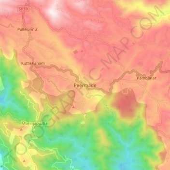
Nome: Mappa topografica Peermade, altitudine, rilievo.
Luogo: Peermade, Peerumade, Idukki, Kerala, 685531, India (9.53201 76.95590 9.61201 77.03590)
Altitudine media: 918 m
Altitudine minima: 300 m
Altitudine massima: 1’399 m
Altre mappe topografiche
Clicca su una mappa per visualizzarne la topografia, l'altitudine e il rilievo.
Periyar National Park Tiger Reserve
Periyar National Park lies in the middle of a mountainous area of the Cardamom Hills. In the north : The boundary commences from the point nearest to the Medaganam in the interstate boundary up to Vellimalai. and the east Thence the boundary follows the inter-state boundary from Vellimalai to Kallimalai Peak…
Altitudine media: 929 m