
Mappa topografica Worcester
Mappa interattiva
Clicca sulla mappa per visualizzare l'altitudine.
A proposito di questa mappa
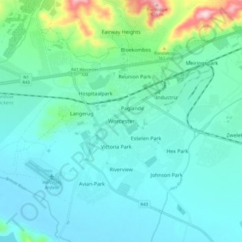
Nome: Mappa topografica Worcester, altitudine, rilievo.
Altitudine media: 252 m
Altitudine minima: 195 m
Altitudine massima: 525 m
Worcester is located at an elevation of 220 metres (720 ft) and can be reached by road either travelling on the N1 highway through the Huguenot Tunnel or by driving through spectacular mountain passes. From Cape Town Du Toitskloof, from Wellington Bainskloof, from Malmesbury, Western Cape Nieuwekloof, from Ceres Mitchells, from Robertson Goree, from Hermanus Rooihoogte and from Johannesburg Hex River, with vistas over the Hex River Valley.
Altre mappe topografiche
Clicca su una mappa per visualizzarne la topografia, l'altitudine e il rilievo.
Touws River
South Africa > Western Cape > Cape Winelands District Municipality > Breede Valley Local Municipality
Touws River, Breede Valley Local Municipality, Cape Winelands District Municipality, Western Cape, South Africa
Altitudine media: 822 m
De Doorns
South Africa > Western Cape > Cape Winelands District Municipality > Breede Valley Local Municipality
De Doorns, Breede Valley Local Municipality, Cape Winelands District Municipality, Western Cape, South Africa
Altitudine media: 683 m
Matroos
South Africa > Western Cape > Cape Winelands District Municipality > Breede Valley Local Municipality
Matroos, Breede Valley Ward 3, Breede Valley Local Municipality, Cape Winelands District Municipality, Western Cape, South Africa
Altitudine media: 1’642 m
Rawsonville
South Africa > Western Cape > Cape Winelands District Municipality > Breede Valley Local Municipality > Rawsonville
Rawsonville, Breede Valley Local Municipality, Cape Winelands District Municipality, Western Cape, South Africa
Altitudine media: 231 m