
Mappa topografica Touws River
Mappa interattiva
Clicca sulla mappa per visualizzare l'altitudine.
A proposito di questa mappa
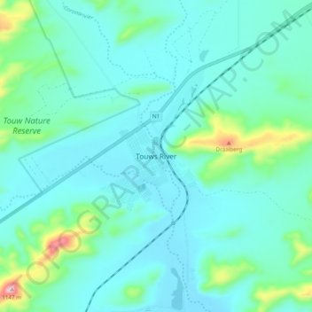
Nome: Mappa topografica Touws River, altitudine, rilievo.
Altitudine media: 822 m
Altitudine minima: 760 m
Altitudine massima: 1’144 m
Touws River is located at an elevation of 770 metres (2,530 ft) on the southwestern edge of the Great Karoo, east of the Hex River Mountains and north of the Langeberg, at the point where the Donkeys River flows into the Touws River. It lies just to the south of the N1 highway, 180 kilometres (110 mi) by road from Cape Town. The railway line passes through the town, with the yards and depot being located just to the north-east; by rail it is 257 kilometres (160 mi) from Cape Town.
Altre mappe topografiche
Clicca su una mappa per visualizzarne la topografia, l'altitudine e il rilievo.
Worcester
South Africa > Western Cape > Cape Winelands District Municipality > Breede Valley Local Municipality
Worcester, Breede Valley Local Municipality, Cape Winelands District Municipality, Western Cape, 6849, South Africa
Altitudine media: 252 m
De Doorns
South Africa > Western Cape > Cape Winelands District Municipality > Breede Valley Local Municipality
De Doorns, Breede Valley Local Municipality, Cape Winelands District Municipality, Western Cape, South Africa
Altitudine media: 683 m
Matroos
South Africa > Western Cape > Cape Winelands District Municipality > Breede Valley Local Municipality
Matroos, Breede Valley Ward 3, Breede Valley Local Municipality, Cape Winelands District Municipality, Western Cape, South Africa
Altitudine media: 1’642 m
Rawsonville
South Africa > Western Cape > Cape Winelands District Municipality > Breede Valley Local Municipality > Rawsonville
Rawsonville, Breede Valley Local Municipality, Cape Winelands District Municipality, Western Cape, South Africa
Altitudine media: 231 m