
Mappa topografica Waverton
Clicca sulla mappa per visualizzare l'altitudine.
A proposito di questa mappa
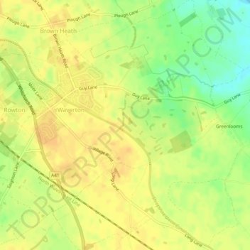
Nome: Mappa topografica Waverton, altitudine, rilievo.
Luogo: Waverton, Cheshire West and Chester, England, United Kingdom (53.15562 -2.82730 53.18351 -2.78243)
Altitudine media: 33 m
Altitudine minima: 14 m
Altitudine massima: 41 m
Altre mappe topografiche
Clicca su una mappa per visualizzarne la topografia, l'altitudine e il rilievo.
Hapsford
United Kingdom > England > Cheshire West and Chester > Dunham on the Hill
Altitudine media: 20 m
Dutton Locks
United Kingdom > England > Cheshire West and Chester > Acton Bridge > Dutton
Altitudine media: 28 m
Countess of Chester Country Park
United Kingdom > England > Cheshire West and Chester > Chester
Altitudine media: 21 m
Delamere Forest
United Kingdom > England > Cheshire West and Chester
This part of Delamere Forest is undulating in character, with elevations predominantly in the range 60–90 metres. It is composed of numerous hummocks and peatland basins, some of which are glacial in origin while others have been created by sand extraction. The basins form lakes and mosses (bogs) within the…
Altitudine media: 90 m
Bolesworth Castle
United Kingdom > England > Cheshire West and Chester > Harthill > Broxton
Altitudine media: 80 m
Bolesworth Fish Pond
United Kingdom > England > Cheshire West and Chester > Harthill > Broxton
Altitudine media: 75 m
Wirral Country Park
United Kingdom > England > Cheshire West and Chester > Neston > Windle Hill
Altitudine media: 49 m
Peckforton Castle
United Kingdom > England > Cheshire West and Chester > Beeston
Peckforton Castle stands in a wooded area near the northern extremity of Peckforton Hills at an elevation of 469.2 feet (143 m). The land falls steeply downwards to the north and the west of the castle, and the Sandstone Trail, a long-distance footpath, runs along the base of these slopes. The ruins of Beeston…
Altitudine media: 83 m
Eddisbury Hill
United Kingdom > England > Cheshire West and Chester > Delamere
Altitudine media: 103 m
Dutton Small Lock (Disused)
United Kingdom > England > Cheshire West and Chester > Acton Bridge > Dutton
Altitudine media: 28 m
Broken Cross
United Kingdom > England > Cheshire West and Chester > Lostock Green
Altitudine media: 28 m
Stamford Bridge
United Kingdom > England > Cheshire West and Chester > Great Barrow
Altitudine media: 24 m
Bostock Green
United Kingdom > England > Cheshire West and Chester > Bostock Green
Altitudine media: 36 m
Eddisbury Hill Fort
United Kingdom > England > Cheshire West and Chester > Delamere
Altitudine media: 103 m
Meadowbank
United Kingdom > England > Cheshire West and Chester > Winsford > Meadowbank
Altitudine media: 40 m
Delamere Forest
United Kingdom > England > Cheshire West and Chester
This part of Delamere Forest is undulating in character, with elevations predominantly in the range 60–90 metres. It is composed of numerous hummocks and peatland basins, some of which are glacial in origin while others have been created by sand extraction. The basins form lakes and mosses (bogs) within the…
Altitudine media: 90 m
Black Diamond Park
United Kingdom > England > Cheshire West and Chester > Chester
Altitudine media: 21 m